

Converted from a KML file using KML2GPX.COM - Track no: 1
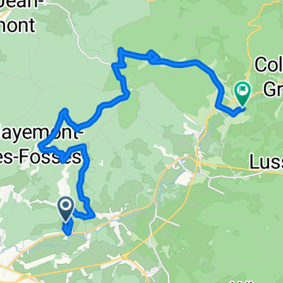
A cycling route starting in Sainte-Marguerite, Alsace-Champagne-Ardenne-Lorraine, France.
Overview
About this route
Converted from a KML file KML2GPX.COM - This is track no: 1
- -:--
- Duration
- 126.5 km
- Distance
- 2,126 m
- Ascent
- 2,288 m
- Descent
- ---
- Avg. speed
- 614 m
- Avg. speed

Route quality
Waytypes & surfaces along the route
Waytypes
Busy road
92.7 km
(73 %)
Road
23 km
(18 %)
Surfaces
Paved
71.6 km
(57 %)
Unpaved
0.6 km
(<1 %)
Asphalt
70.9 km
(56 %)
Gravel
0.6 km
(<1 %)
Continue with Bikemap
Use, edit, or download this cycling route
You would like to ride Converted from a KML file using KML2GPX.COM - Track no: 1 or customize it for your own trip? Here is what you can do with this Bikemap route:
Free features
- Save this route as favorite or in collections
- Copy & plan your own version of this route
- Sync your route with Garmin or Wahoo
Premium features
Free trial for 3 days, or one-time payment. More about Bikemap Premium.
- Navigate this route on iOS & Android
- Export a GPX / KML file of this route
- Create your custom printout (try it for free)
- Download this route for offline navigation
Discover more Premium features.
Get Bikemap PremiumFrom our community
Other popular routes starting in Sainte-Marguerite
 Récup !
- Distance
- 64.9 km
- Ascent
- 519 m
- Descent
- 439 m
- Location
- Sainte-Marguerite, Alsace-Champagne-Ardenne-Lorraine, France
 221 Route des Coteaux, Pair-et-Grandrupt à 2–5 Route des Crêtes, Urbeis
- Distance
- 19.5 km
- Ascent
- 350 m
- Descent
- 61 m
- Location
- Sainte-Marguerite, Alsace-Champagne-Ardenne-Lorraine, France
 88 04c 30km Frapelle
- Distance
- 27.9 km
- Ascent
- 788 m
- Descent
- 780 m
- Location
- Sainte-Marguerite, Alsace-Champagne-Ardenne-Lorraine, France
 TDF neu 9. Etappe St. Die des Vosges - Grand Ballon
- Distance
- 176.3 km
- Ascent
- 4,422 m
- Descent
- 3,443 m
- Location
- Sainte-Marguerite, Alsace-Champagne-Ardenne-Lorraine, France
 Vosges JP
- Distance
- 119.2 km
- Ascent
- 1,699 m
- Descent
- 1,821 m
- Location
- Sainte-Marguerite, Alsace-Champagne-Ardenne-Lorraine, France
 QSDEF
QSDEF- Distance
- 403.7 km
- Ascent
- 3,989 m
- Descent
- 3,965 m
- Location
- Sainte-Marguerite, Alsace-Champagne-Ardenne-Lorraine, France
 Récupération
- Distance
- 45.1 km
- Ascent
- 434 m
- Descent
- 401 m
- Location
- Sainte-Marguerite, Alsace-Champagne-Ardenne-Lorraine, France
 hhhhjku
- Distance
- 187.4 km
- Ascent
- 3,224 m
- Descent
- 3,215 m
- Location
- Sainte-Marguerite, Alsace-Champagne-Ardenne-Lorraine, France
Open it in the app