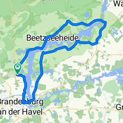
HVL Brandenburg 7-Seen #36
A cycling route starting in Brandenburg, Brandenburg, Germany.
Overview
About this route
Leider eher enttäuschend - zumindest wenn man Verkehrsferne und weite Landschaften sucht. Bis Wilhelmsdorf strassenbegleitrender Radweg. Über Malge und Kirchmöser asphaltierter Radweg durch den Wald mit gelegentlichen sehr schönen Ausblicken auf die Havelseen. Nach dem Schlosspark Plaue führt (z.Zt. - 2022 kleiner Umweg über 'Kietzstrasse' wg. Brückensperrung) strassenbegleitener Asphalt an ewiggleichen Nadelbäumen zum Silokanal, wo ein superbes Kiesufer zu den schöneren Teilen des eher abseitigen Brandenburg führt.
Start & Ende: Hauptbahnhof
- -:--
- Duration
- 34.6 km
- Distance
- 93 m
- Ascent
- 95 m
- Descent
- ---
- Avg. speed
- 43 m
- Avg. speed
Route quality
Waytypes & surfaces along the route
Waytypes
Path
19.5 km
(56 %)
Quiet road
9 km
(26 %)
Surfaces
Paved
27.2 km
(79 %)
Unpaved
3.2 km
(9 %)
Asphalt
18.4 km
(53 %)
Paved (undefined)
5.3 km
(15 %)
Continue with Bikemap
Use, edit, or download this cycling route
You would like to ride HVL Brandenburg 7-Seen #36 or customize it for your own trip? Here is what you can do with this Bikemap route:
Free features
- Save this route as favorite or in collections
- Copy & plan your own version of this route
- Sync your route with Garmin or Wahoo
Premium features
Free trial for 3 days, or one-time payment. More about Bikemap Premium.
- Navigate this route on iOS & Android
- Export a GPX / KML file of this route
- Create your custom printout (try it for free)
- Download this route for offline navigation
Discover more Premium features.
Get Bikemap PremiumFrom our community
Other popular routes starting in Brandenburg
 nächste Tour
- Distance
- 40.1 km
- Ascent
- 31 m
- Descent
- 29 m
- Location
- Brandenburg, Brandenburg, Germany
 Nördlich um die Stadt Brandenburg bis ins Havelland
- Distance
- 85 km
- Ascent
- 106 m
- Descent
- 109 m
- Location
- Brandenburg, Brandenburg, Germany
 Rund um BRB am Wasser
- Distance
- 55.2 km
- Ascent
- 84 m
- Descent
- 83 m
- Location
- Brandenburg, Brandenburg, Germany
 Recovered Route
- Distance
- 18.5 km
- Ascent
- 3 m
- Descent
- 6 m
- Location
- Brandenburg, Brandenburg, Germany
 Dominsel - Vorstadtschleuse - Brandenburg - Beetzsee
- Distance
- 30.5 km
- Ascent
- 39 m
- Descent
- 38 m
- Location
- Brandenburg, Brandenburg, Germany
 BRB - Päwesin - BRB
- Distance
- 37.6 km
- Ascent
- 68 m
- Descent
- 69 m
- Location
- Brandenburg, Brandenburg, Germany
 Havelradweg Brandenburg - Werder
- Distance
- 43.8 km
- Ascent
- 75 m
- Descent
- 72 m
- Location
- Brandenburg, Brandenburg, Germany
 Meine Seerunde
- Distance
- 38.3 km
- Ascent
- 78 m
- Descent
- 80 m
- Location
- Brandenburg, Brandenburg, Germany
Open it in the app


