

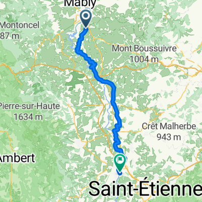
Itinéraire modéré en
A cycling route starting in Commelle-Vernay, Auvergne-Rhône-Alpes, France.
Overview
About this route
- 1 h 19 min
- Duration
- 18.4 km
- Distance
- 239 m
- Ascent
- 238 m
- Descent
- 14 km/h
- Avg. speed
- 486 m
- Avg. speed

Route quality
Waytypes & surfaces along the route
Waytypes
Road
8.8 km
(48 %)
Busy road
7.2 km
(39 %)
Continue with Bikemap
Use, edit, or download this cycling route
You would like to ride Itinéraire modéré en or customize it for your own trip? Here is what you can do with this Bikemap route:
Free features
- Save this route as favorite or in collections
- Copy & plan your own version of this route
- Sync your route with Garmin or Wahoo
Premium features
Free trial for 3 days, or one-time payment. More about Bikemap Premium.
- Navigate this route on iOS & Android
- Export a GPX / KML file of this route
- Create your custom printout (try it for free)
- Download this route for offline navigation
Discover more Premium features.
Get Bikemap PremiumFrom our community
Other popular routes starting in Commelle-Vernay
 Championnats AUVRA 2018
- Distance
- 7.7 km
- Ascent
- 136 m
- Descent
- 139 m
- Location
- Commelle-Vernay, Auvergne-Rhône-Alpes, France
 De Chemin des Beaux Lieux 340, Commelle-Vernay à Chemin des Beaux Lieux 340, Commelle-Vernay
- Distance
- 28.2 km
- Ascent
- 50 m
- Descent
- 166 m
- Location
- Commelle-Vernay, Auvergne-Rhône-Alpes, France
 Itinéraire modéré en
- Distance
- 18.4 km
- Ascent
- 239 m
- Descent
- 238 m
- Location
- Commelle-Vernay, Auvergne-Rhône-Alpes, France
 Gare de Roanne to Chateau d'Ailley
- Distance
- 6.2 km
- Ascent
- 19 m
- Descent
- 51 m
- Location
- Commelle-Vernay, Auvergne-Rhône-Alpes, France
 De 13 Impasse des Boutons d'Or, Commelle-Vernay à 13 Impasse des Boutons d'Or, Commelle-Vernay
- Distance
- 14.9 km
- Ascent
- 212 m
- Descent
- 209 m
- Location
- Commelle-Vernay, Auvergne-Rhône-Alpes, France
 2023.3 Parigny - Digoin-Paray le Monial
- Distance
- 77.5 km
- Ascent
- 149 m
- Descent
- 228 m
- Location
- Commelle-Vernay, Auvergne-Rhône-Alpes, France
 2. Tag Roanne - Saint Just
- Distance
- 83.8 km
- Ascent
- 722 m
- Descent
- 662 m
- Location
- Commelle-Vernay, Auvergne-Rhône-Alpes, France
 20130830_085353.gpx
- Distance
- 121.9 km
- Ascent
- 1,438 m
- Descent
- 1,262 m
- Location
- Commelle-Vernay, Auvergne-Rhône-Alpes, France
Open it in the app