
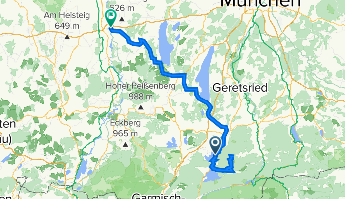
Kochel am See, Landsberg am Lech
A cycling route starting in Kochel, Bavaria, Germany.
Overview
About this route
- -:--
- Duration
- 130.5 km
- Distance
- 2,433 m
- Ascent
- 2,473 m
- Descent
- ---
- Avg. speed
- 1,333 m
- Avg. speed

Route quality
Waytypes & surfaces along the route
Waytypes
Track
34.7 km
(27 %)
Quiet road
34.5 km
(26 %)
Surfaces
Paved
91.1 km
(70 %)
Unpaved
30.1 km
(23 %)
Asphalt
89.7 km
(69 %)
Gravel
21.7 km
(17 %)
Continue with Bikemap
Use, edit, or download this cycling route
You would like to ride Kochel am See, Landsberg am Lech or customize it for your own trip? Here is what you can do with this Bikemap route:
Free features
- Save this route as favorite or in collections
- Copy & plan your own version of this route
- Sync your route with Garmin or Wahoo
Premium features
Free trial for 3 days, or one-time payment. More about Bikemap Premium.
- Navigate this route on iOS & Android
- Export a GPX / KML file of this route
- Create your custom printout (try it for free)
- Download this route for offline navigation
Discover more Premium features.
Get Bikemap PremiumFrom our community
Other popular routes starting in Kochel
 Kochel Jochberg Trimini
- Distance
- 31.4 km
- Ascent
- 1,035 m
- Descent
- 1,041 m
- Location
- Kochel, Bavaria, Germany
 Kochel - Jocheralm
- Distance
- 17.1 km
- Ascent
- 743 m
- Descent
- 233 m
- Location
- Kochel, Bavaria, Germany
 Kocheler Alm
- Distance
- 12.8 km
- Ascent
- 632 m
- Descent
- 632 m
- Location
- Kochel, Bavaria, Germany
 Bodensee-Königssee-Radweg V (Kochel - Schliersee)
- Distance
- 64 km
- Ascent
- 546 m
- Descent
- 298 m
- Location
- Kochel, Bavaria, Germany
 A3 Kochelsee-Penzberg
- Distance
- 57.8 km
- Ascent
- 438 m
- Descent
- 456 m
- Location
- Kochel, Bavaria, Germany
 Kochel - Jachenau - Kochel
- Distance
- 30.6 km
- Ascent
- 1,181 m
- Descent
- 1,157 m
- Location
- Kochel, Bavaria, Germany
 Um den Kochel See 2
- Distance
- 19 km
- Ascent
- 455 m
- Descent
- 480 m
- Location
- Kochel, Bavaria, Germany
 Jochberg über Fieberkapellenweg
- Distance
- 22.3 km
- Ascent
- 805 m
- Descent
- 812 m
- Location
- Kochel, Bavaria, Germany
Open it in the app