

Parcours vélo du Cézallier - Autour du massif du Sancy (Boucle n°10) - Parcours vélo du Cézallier - Autour du massif du Sancy (Boucle n°10)
A cycling route starting in Le Mont-Dore, Auvergne-Rhône-Alpes, France.
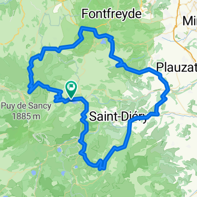
Overview
About this route
Ce circuit vélo vous propose de découvrir le Massif du Sancy, de hauts plateaux granitiques recouverts par de coulées volcaniques ou de vastes étendues de pâturage avec des burons.
- -:--
- Duration
- 89.2 km
- Distance
- 1,617 m
- Ascent
- 1,617 m
- Descent
- ---
- Avg. speed
- 1,224 m
- Avg. speed
Route quality
Waytypes & surfaces along the route
Waytypes
Road
69.4 km
(78 %)
Busy road
19 km
(21 %)
Surfaces
Paved
65.2 km
(73 %)
Asphalt
65.2 km
(73 %)
Undefined
24 km
(27 %)
Continue with Bikemap
Use, edit, or download this cycling route
You would like to ride Parcours vélo du Cézallier - Autour du massif du Sancy (Boucle n°10) - Parcours vélo du Cézallier - Autour du massif du Sancy (Boucle n°10) or customize it for your own trip? Here is what you can do with this Bikemap route:
Free features
- Save this route as favorite or in collections
- Copy & plan your own version of this route
- Sync your route with Garmin or Wahoo
Premium features
Free trial for 3 days, or one-time payment. More about Bikemap Premium.
- Navigate this route on iOS & Android
- Export a GPX / KML file of this route
- Create your custom printout (try it for free)
- Download this route for offline navigation
Discover more Premium features.
Get Bikemap PremiumFrom our community
Other popular routes starting in Le Mont-Dore
 Auvergne1
- Distance
- 45.2 km
- Ascent
- 1,443 m
- Descent
- 1,448 m
- Location
- Le Mont-Dore, Auvergne-Rhône-Alpes, France
 Mont-Dore Trip#2 80km
- Distance
- 80.9 km
- Ascent
- 1,649 m
- Descent
- 1,604 m
- Location
- Le Mont-Dore, Auvergne-Rhône-Alpes, France
 Boucle Est Mont Dore
- Distance
- 93.6 km
- Ascent
- 1,610 m
- Descent
- 1,612 m
- Location
- Le Mont-Dore, Auvergne-Rhône-Alpes, France
 2019-25 Le-Mont-Dore to Riom-ès-Montagnes
- Distance
- 60.4 km
- Ascent
- 716 m
- Descent
- 893 m
- Location
- Le Mont-Dore, Auvergne-Rhône-Alpes, France
 Mont dore tour du lac Chambon
- Distance
- 38.6 km
- Ascent
- 938 m
- Descent
- 938 m
- Location
- Le Mont-Dore, Auvergne-Rhône-Alpes, France
 France 4 - Massif Central 2
- Distance
- 107.7 km
- Ascent
- 1,542 m
- Descent
- 1,542 m
- Location
- Le Mont-Dore, Auvergne-Rhône-Alpes, France
 Mont-Dore Trip#1 60km
- Distance
- 57 km
- Ascent
- 1,158 m
- Descent
- 1,134 m
- Location
- Le Mont-Dore, Auvergne-Rhône-Alpes, France
 3.etapa Mont-Dore - Riom-es-Montagnes
- Distance
- 71.2 km
- Ascent
- 1,218 m
- Descent
- 1,380 m
- Location
- Le Mont-Dore, Auvergne-Rhône-Alpes, France
Open it in the app