

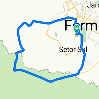
Trilha Toca da Onça - Formosa/GO
A cycling route starting in Formosa, Goiás, Brazil.
Overview
About this route
- 2 h 50 min
- Duration
- 40 km
- Distance
- 851 m
- Ascent
- 854 m
- Descent
- 14.1 km/h
- Avg. speed
- 961 m
- Avg. speed

Continue with Bikemap
Use, edit, or download this cycling route
You would like to ride Trilha Toca da Onça - Formosa/GO or customize it for your own trip? Here is what you can do with this Bikemap route:
Free features
- Save this route as favorite or in collections
- Copy & plan your own version of this route
- Sync your route with Garmin or Wahoo
Premium features
Free trial for 3 days, or one-time payment. More about Bikemap Premium.
- Navigate this route on iOS & Android
- Export a GPX / KML file of this route
- Create your custom printout (try it for free)
- Download this route for offline navigation
Discover more Premium features.
Get Bikemap PremiumFrom our community
Other popular routes starting in Formosa
 De Rua Vinte e Oito 691 a Rua Vinte e Oito n 691
- Distance
- 18.2 km
- Ascent
- 149 m
- Descent
- 129 m
- Location
- Formosa, Goiás, Brazil
 Trilha Toca da Onça - Formosa/GO
- Distance
- 40 km
- Ascent
- 851 m
- Descent
- 854 m
- Location
- Formosa, Goiás, Brazil
 dia 2
dia 2- Distance
- 10.8 km
- Ascent
- 1 m
- Descent
- 4 m
- Location
- Formosa, Goiás, Brazil
 De Rua 3 351a a Rua Auta Vidal 1114
- Distance
- 3 km
- Ascent
- 510 m
- Descent
- 472 m
- Location
- Formosa, Goiás, Brazil
 De Avenida Circular 15 a Avenida Circular 15
- Distance
- 18.9 km
- Ascent
- 242 m
- Descent
- 246 m
- Location
- Formosa, Goiás, Brazil
 De Rua Vinte e Oito n 691 a Rua Vinte e Oito 691
- Distance
- 19.6 km
- Ascent
- 153 m
- Descent
- 156 m
- Location
- Formosa, Goiás, Brazil
 Pedal Bezerra - BR 020
- Distance
- 63.1 km
- Ascent
- 765 m
- Descent
- 765 m
- Location
- Formosa, Goiás, Brazil
 dia 1
dia 1- Distance
- 12.1 km
- Ascent
- 88 m
- Descent
- 94 m
- Location
- Formosa, Goiás, Brazil
Open it in the app