

Blato 26
A cycling route starting in Nová Bystřice, Jihočeský kraj, Czechia.
Overview
About this route
28.7.2006
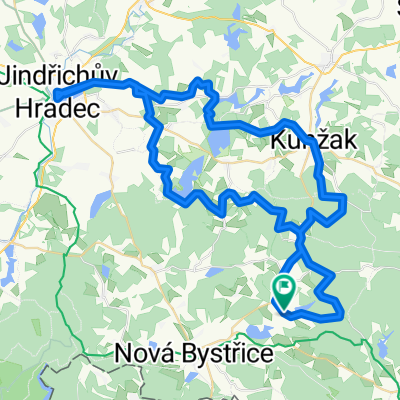
BLATO – KLÁŠTER – MÝTINKY – REINGERS – KAUTZEN – KLEIN-TAXEN – STARÉ MĚSTO – LANDŠTEJN - BLATO<br /><br />Blato – polní – lesní – Klášter – do kopce – po polní cestě – Mýtinky – kravín – na silnici doleva – po 1007 – sjezd silnicí – něm.kamenný rozcestník – doleva – rozcestí – doleva lesem – asfalt –<br />Starohuťský vrch – Staré Hutě - odbočka vlevo – 1007b – lesem – st.hranice – Kalkberghauser – sjezd silnicí – Reingers – doleva po polní – 50 – lesem - Parten – Reinberg-Dobersberg – po Waldviertelweg – Radschin ( evropské rozvodí ) – po silnici – Illmau – Kautzen – po silnici vlevo – Gross-Taxen – 3 – silnice - stoupání – Klein-Taxen – hr. přechod – Košťálkov – po silnici – po 1007 – Staré Město – panelovou cestou – dětský tábor – přehrada – po hrázi – doprava – po vrstevnici lesem – Landštejn – Holubník – po 32 – silnice – klesání – stoupák – Jelení – lesní – polní cestou - Blato
- -:--
- Duration
- 45.7 km
- Distance
- 398 m
- Ascent
- 398 m
- Descent
- ---
- Avg. speed
- ---
- Max. altitude

Route quality
Waytypes & surfaces along the route
Waytypes
Road
21 km
(46 %)
Track
19.6 km
(43 %)
Surfaces
Paved
16.5 km
(36 %)
Unpaved
8.7 km
(19 %)
Paved (undefined)
9.1 km
(20 %)
Asphalt
5.5 km
(12 %)
Continue with Bikemap
Use, edit, or download this cycling route
You would like to ride Blato 26 or customize it for your own trip? Here is what you can do with this Bikemap route:
Free features
- Save this route as favorite or in collections
- Copy & plan your own version of this route
- Sync your route with Garmin or Wahoo
Premium features
Free trial for 3 days, or one-time payment. More about Bikemap Premium.
- Navigate this route on iOS & Android
- Export a GPX / KML file of this route
- Create your custom printout (try it for free)
- Download this route for offline navigation
Discover more Premium features.
Get Bikemap PremiumFrom our community
Other popular routes starting in Nová Bystřice
 Kunějov, dobrá trasa, terén :-)
- Distance
- 45.6 km
- Ascent
- 473 m
- Descent
- 471 m
- Location
- Nová Bystřice, Jihočeský kraj, Czechia
 Nová Bystřice - Grafenwörth
- Distance
- 138.6 km
- Ascent
- 1,281 m
- Descent
- 1,679 m
- Location
- Nová Bystřice, Jihočeský kraj, Czechia
 Výlet do Litschau
- Distance
- 34.4 km
- Ascent
- 335 m
- Descent
- 351 m
- Location
- Nová Bystřice, Jihočeský kraj, Czechia
 Nová Bystřice - Planá nad Lužnicí
- Distance
- 49.4 km
- Ascent
- 480 m
- Descent
- 616 m
- Location
- Nová Bystřice, Jihočeský kraj, Czechia
 Blato 24
- Distance
- 66.6 km
- Ascent
- 526 m
- Descent
- 526 m
- Location
- Nová Bystřice, Jihočeský kraj, Czechia
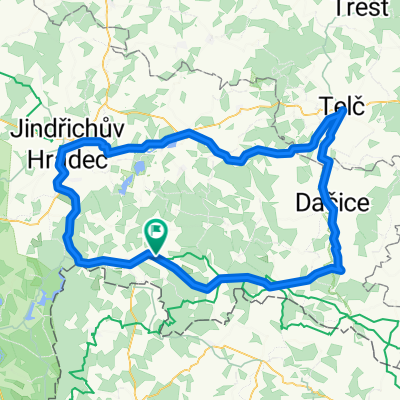 Albeř- Telč - větší okruh
- Distance
- 118.3 km
- Ascent
- 758 m
- Descent
- 756 m
- Location
- Nová Bystřice, Jihočeský kraj, Czechia
 EAPE 10 OSIKA - NACHOD
- Distance
- 77.2 km
- Ascent
- 444 m
- Descent
- 645 m
- Location
- Nová Bystřice, Jihočeský kraj, Czechia
 Blato 26
- Distance
- 45.7 km
- Ascent
- 398 m
- Descent
- 398 m
- Location
- Nová Bystřice, Jihočeský kraj, Czechia
Open it in the app