

Mytos by Panther 3
A cycling route starting in Tonadico, Trentino-Alto Adige, Italy.
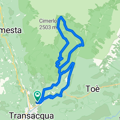
Overview
About this route
null
- 10 h 7 min
- Duration
- 48.8 km
- Distance
- 2,036 m
- Ascent
- 2,038 m
- Descent
- 4.8 km/h
- Avg. speed
- 1,699 m
- Avg. speed

Route photos


Route quality
Waytypes & surfaces along the route
Waytypes
Track
25.5 km
(52 %)
Path
11 km
(23 %)
Surfaces
Paved
4.2 km
(9 %)
Unpaved
18.4 km
(38 %)
Unpaved (undefined)
7.3 km
(15 %)
Ground
6.8 km
(14 %)
Continue with Bikemap
Use, edit, or download this cycling route
You would like to ride Mytos by Panther 3 or customize it for your own trip? Here is what you can do with this Bikemap route:
Free features
- Save this route as favorite or in collections
- Copy & plan your own version of this route
- Sync your route with Garmin or Wahoo
Premium features
Free trial for 3 days, or one-time payment. More about Bikemap Premium.
- Navigate this route on iOS & Android
- Export a GPX / KML file of this route
- Create your custom printout (try it for free)
- Download this route for offline navigation
Discover more Premium features.
Get Bikemap PremiumFrom our community
Other popular routes starting in Tonadico
 Tonadico, Tognola, Forcella Val Sorda, Zortea, Tonadico
- Distance
- 46.8 km
- Ascent
- 1,874 m
- Descent
- 1,874 m
- Location
- Tonadico, Trentino-Alto Adige, Italy
 lago di calaita mtb
- Distance
- 28.2 km
- Ascent
- 984 m
- Descent
- 984 m
- Location
- Tonadico, Trentino-Alto Adige, Italy
 Tonadico, Val Belluna, Valle del MIs
- Distance
- 100.8 km
- Ascent
- 1,558 m
- Descent
- 1,528 m
- Location
- Tonadico, Trentino-Alto Adige, Italy
 val canali da tonadico mtb
- Distance
- 22.2 km
- Ascent
- 967 m
- Descent
- 967 m
- Location
- Tonadico, Trentino-Alto Adige, Italy
 LiAn24_8
- Distance
- 66 km
- Ascent
- 1,892 m
- Descent
- 2,697 m
- Location
- Tonadico, Trentino-Alto Adige, Italy
 rif. vederna
- Distance
- 50.1 km
- Ascent
- 1,451 m
- Descent
- 1,450 m
- Location
- Tonadico, Trentino-Alto Adige, Italy
 GgGiro2019Etapa19Mis
- Distance
- 22.6 km
- Ascent
- 901 m
- Descent
- 904 m
- Location
- Tonadico, Trentino-Alto Adige, Italy
 GgGiro2019Etapa19
- Distance
- 45.4 km
- Ascent
- 1,253 m
- Descent
- 1,256 m
- Location
- Tonadico, Trentino-Alto Adige, Italy
Open it in the app