

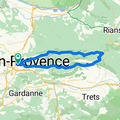
Groene Weg naar de Middellandse Zee - Compleet
A cycling route starting in Aix-en-Provence, Provence-Alpes-Côte d'Azur Region, France.
Overview
About this route
Complete fietsroute vanaf Aix-en-Provence naar Voorhout volgens de beschreven route Groene Weg naar de Middellandse Zee.Let op: deze route loopt dus vanaf Zuid-Frankrijk terug naar Nederland.
- -:--
- Duration
- 1,808.9 km
- Distance
- 15,620 m
- Ascent
- 15,790 m
- Descent
- ---
- Avg. speed
- 603 m
- Avg. speed
Route quality
Waytypes & surfaces along the route
Waytypes
Road
566.5 km
(31 %)
Quiet road
383.7 km
(21 %)
Surfaces
Paved
948.7 km
(52 %)
Unpaved
151 km
(8 %)
Asphalt
860.9 km
(48 %)
Gravel
78.1 km
(4 %)
Continue with Bikemap
Use, edit, or download this cycling route
You would like to ride Groene Weg naar de Middellandse Zee - Compleet or customize it for your own trip? Here is what you can do with this Bikemap route:
Free features
- Save this route as favorite or in collections
- Copy & plan your own version of this route
- Sync your route with Garmin or Wahoo
Premium features
Free trial for 3 days, or one-time payment. More about Bikemap Premium.
- Navigate this route on iOS & Android
- Export a GPX / KML file of this route
- Create your custom printout (try it for free)
- Download this route for offline navigation
Discover more Premium features.
Get Bikemap PremiumFrom our community
Other popular routes starting in Aix-en-Provence
 Tout De La Sainte Victoire
- Distance
- 54.4 km
- Ascent
- 984 m
- Descent
- 778 m
- Location
- Aix-en-Provence, Provence-Alpes-Côte d'Azur Region, France
 Bibémus-bimont-doudon
- Distance
- 26.3 km
- Ascent
- 418 m
- Descent
- 421 m
- Location
- Aix-en-Provence, Provence-Alpes-Côte d'Azur Region, France
 Route in Aix-en-Provence
- Distance
- 28.7 km
- Ascent
- 461 m
- Descent
- 457 m
- Location
- Aix-en-Provence, Provence-Alpes-Côte d'Azur Region, France
 Marseille-5c: Rundtour Montagne Ste Victoire
- Distance
- 56.7 km
- Ascent
- 791 m
- Descent
- 791 m
- Location
- Aix-en-Provence, Provence-Alpes-Côte d'Azur Region, France
 From Aix-en-Provence to Charleval
- Distance
- 33.8 km
- Ascent
- 509 m
- Descent
- 572 m
- Location
- Aix-en-Provence, Provence-Alpes-Côte d'Azur Region, France
 Boucle au sud d'aix en provence
- Distance
- 42.8 km
- Ascent
- 289 m
- Descent
- 292 m
- Location
- Aix-en-Provence, Provence-Alpes-Côte d'Azur Region, France
 Sud-est d'aix en provence
- Distance
- 57 km
- Ascent
- 531 m
- Descent
- 524 m
- Location
- Aix-en-Provence, Provence-Alpes-Côte d'Azur Region, France
 Route in Aix-en-Provence
- Distance
- 110.1 km
- Ascent
- 1,855 m
- Descent
- 1,853 m
- Location
- Aix-en-Provence, Provence-Alpes-Côte d'Azur Region, France
Open it in the app