

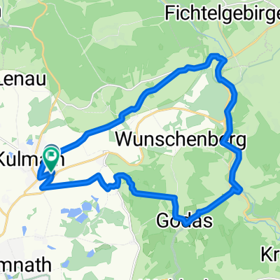
Himmelsleiter-Ochsenkopf 16.08.11
A cycling route starting in Kulmain, Bavaria, Germany.
Overview
About this route
Ab Kulmain-Haideaab-Tressau-Fischbach bis Görau geht es fast immer leicht Bergauf,von Untersteinach,den Krebsbach entlang über die Himmelsleiter bis zum Ochsenkopf muß man dann schon kräftiger in die Pedalle treten,über ca 20km,(mit Umleitung wegen Forstarbeiten),von nunan beginnen wir die Heimreise über Neubau-BT Haus-Ölbrunn-Alm nach Kulmain.
- -:--
- Duration
- 70.9 km
- Distance
- 950 m
- Ascent
- 950 m
- Descent
- ---
- Avg. speed
- ---
- Avg. speed
Route quality
Waytypes & surfaces along the route
Waytypes
Track
37.6 km
(53 %)
Quiet road
15.9 km
(22 %)
Surfaces
Paved
9.7 km
(14 %)
Unpaved
39.8 km
(56 %)
Gravel
34.3 km
(48 %)
Asphalt
6.2 km
(9 %)
Continue with Bikemap
Use, edit, or download this cycling route
You would like to ride Himmelsleiter-Ochsenkopf 16.08.11 or customize it for your own trip? Here is what you can do with this Bikemap route:
Free features
- Save this route as favorite or in collections
- Copy & plan your own version of this route
- Sync your route with Garmin or Wahoo
Premium features
Free trial for 3 days, or one-time payment. More about Bikemap Premium.
- Navigate this route on iOS & Android
- Export a GPX / KML file of this route
- Create your custom printout (try it for free)
- Download this route for offline navigation
Discover more Premium features.
Get Bikemap PremiumFrom our community
Other popular routes starting in Kulmain
 Ochsenkopfgipfel
- Distance
- 58.1 km
- Ascent
- 819 m
- Descent
- 819 m
- Location
- Kulmain, Bavaria, Germany
 Armesberg-Tour
- Distance
- 18.4 km
- Ascent
- 340 m
- Descent
- 340 m
- Location
- Kulmain, Bavaria, Germany
 Himmelsleiter-Ochsenkopf 16.08.11
- Distance
- 70.9 km
- Ascent
- 950 m
- Descent
- 950 m
- Location
- Kulmain, Bavaria, Germany
 Kulmain-Königskron-Schneeberg-Kulmain
- Distance
- 61.1 km
- Ascent
- 877 m
- Descent
- 877 m
- Location
- Kulmain, Bavaria, Germany
 Kulmain nach Waldhaus, rotwildgehege
- Distance
- 14.6 km
- Ascent
- 544 m
- Descent
- 202 m
- Location
- Kulmain, Bavaria, Germany
 OMFG
OMFG- Distance
- 61.3 km
- Ascent
- 552 m
- Descent
- 552 m
- Location
- Kulmain, Bavaria, Germany
 Fünf-Berge-Tour 12.08.2011
- Distance
- 88.9 km
- Ascent
- 1,613 m
- Descent
- 1,613 m
- Location
- Kulmain, Bavaria, Germany
 Mountian bike, w/free ride thru woods
- Distance
- 19 km
- Ascent
- 365 m
- Descent
- 367 m
- Location
- Kulmain, Bavaria, Germany
Open it in the app