
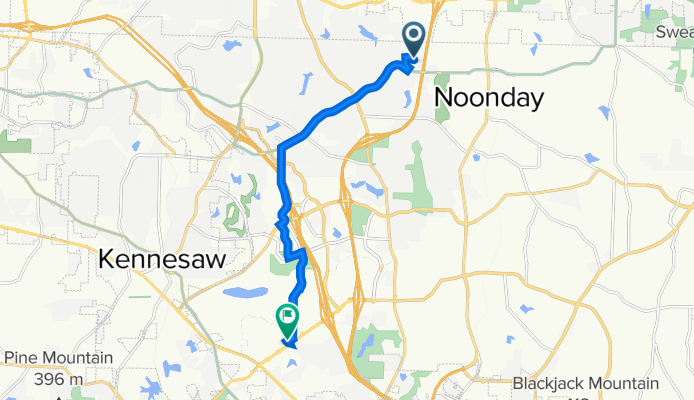
4946 Dana Dr NE, Kennesaw to 954 Ernest W Barrett Pkwy NW, Kennesaw
A cycling route starting in Woodstock, Georgia, United States of America.
Overview
About this route
- 45 min
- Duration
- 11.1 km
- Distance
- 125 m
- Ascent
- 111 m
- Descent
- 14.9 km/h
- Avg. speed
- 350 m
- Avg. speed

Route quality
Waytypes & surfaces along the route
Waytypes
Road
4 km
(37 %)
Busy road
2.9 km
(27 %)
Surfaces
Paved
8.8 km
(80 %)
Asphalt
7.7 km
(69 %)
Concrete
1.1 km
(10 %)
Undefined
2.3 km
(20 %)
Continue with Bikemap
Use, edit, or download this cycling route
You would like to ride 4946 Dana Dr NE, Kennesaw to 954 Ernest W Barrett Pkwy NW, Kennesaw or customize it for your own trip? Here is what you can do with this Bikemap route:
Free features
- Save this route as favorite or in collections
- Copy & plan your own version of this route
- Sync your route with Garmin or Wahoo
Premium features
Free trial for 3 days, or one-time payment. More about Bikemap Premium.
- Navigate this route on iOS & Android
- Export a GPX / KML file of this route
- Create your custom printout (try it for free)
- Download this route for offline navigation
Discover more Premium features.
Get Bikemap PremiumFrom our community
Other popular routes starting in Woodstock
 To/from Performance
- Distance
- 41.5 km
- Ascent
- 269 m
- Descent
- 277 m
- Location
- Woodstock, Georgia, United States of America
 1470 Towne Lake Pkwy, Woodstock to 50 Paces Pkwy, Woodstock
- Distance
- 13.9 km
- Ascent
- 166 m
- Descent
- 152 m
- Location
- Woodstock, Georgia, United States of America
 Olde Rope Mill Park past Waterfall turnoff
- Distance
- 9 km
- Ascent
- 356 m
- Descent
- 357 m
- Location
- Woodstock, Georgia, United States of America
 4946 Dana Dr NE, Kennesaw to 954 Ernest W Barrett Pkwy NW, Kennesaw
- Distance
- 11.1 km
- Ascent
- 125 m
- Descent
- 111 m
- Location
- Woodstock, Georgia, United States of America
 Restful route in drupe park
- Distance
- 0.3 km
- Ascent
- 4 m
- Descent
- 4 m
- Location
- Woodstock, Georgia, United States of America
 2014 Route1
- Distance
- 53.6 km
- Ascent
- 348 m
- Descent
- 346 m
- Location
- Woodstock, Georgia, United States of America
 Cracking ride in Marietta
- Distance
- 18.3 km
- Ascent
- 233 m
- Descent
- 236 m
- Location
- Woodstock, Georgia, United States of America
 Hell
Hell- Distance
- 49 km
- Ascent
- 537 m
- Descent
- 553 m
- Location
- Woodstock, Georgia, United States of America
Open it in the app