

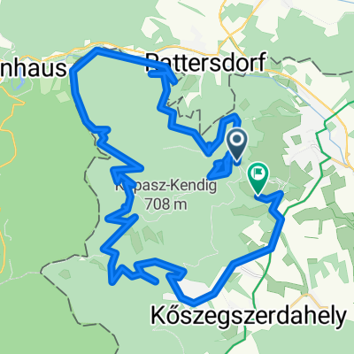
MTB Trails
A cycling route starting in Kőszeg, Vas, Hungary.
Overview
About this route
- -:--
- Duration
- 21 km
- Distance
- 808 m
- Ascent
- 848 m
- Descent
- ---
- Avg. speed
- 874 m
- Avg. speed

Route quality
Waytypes & surfaces along the route
Waytypes
Track
11 km
(53 %)
Path
5.3 km
(25 %)
Surfaces
Paved
5.1 km
(24 %)
Unpaved
13.9 km
(67 %)
Ground
10.4 km
(50 %)
Paved (undefined)
3.8 km
(18 %)
Route highlights
Points of interest along the route
Point of interest after 2.6 km
MTB Trail 1 End
Point of interest after 2.6 km
MTB Trail 2 End
Point of interest after 5.5 km
MTB Trail 2
Point of interest after 6 km
MTB Trail 1 Start
Point of interest after 7 km
MTB Trail 2 Start
Point of interest after 7.3 km
Unicum End
Point of interest after 8.3 km
Unicum Start
Point of interest after 10.5 km
Átkötő Start
Point of interest after 10.7 km
Átkötő End
Point of interest after 10.9 km
Lócomb Start
Point of interest after 14.7 km
VK 1 Start
Point of interest after 14.8 km
Kincs Pihenő - VK Access
Point of interest after 14.8 km
Irányhegy Transfer
Point of interest after 14.8 km
VK Transfer
Point of interest after 15.2 km
Ban 2 Start
Point of interest after 15.3 km
VK 1 End
Point of interest after 15.4 km
IH 2 Start
Point of interest after 15.4 km
Irány Hegy Start
Point of interest after 16 km
Ban 2 End
Point of interest after 16.2 km
Irány hegy End
Point of interest after 16.6 km
IH 2 End
Point of interest after 16.8 km
Kincs Pihenő - VK access (cross)
Point of interest after 18.3 km
Kincs Pihenő - VK Access (cross)
Continue with Bikemap
Use, edit, or download this cycling route
You would like to ride MTB Trails or customize it for your own trip? Here is what you can do with this Bikemap route:
Free features
- Save this route as favorite or in collections
- Copy & plan your own version of this route
- Sync your route with Garmin or Wahoo
Premium features
Free trial for 3 days, or one-time payment. More about Bikemap Premium.
- Navigate this route on iOS & Android
- Export a GPX / KML file of this route
- Create your custom printout (try it for free)
- Download this route for offline navigation
Discover more Premium features.
Get Bikemap PremiumFrom our community
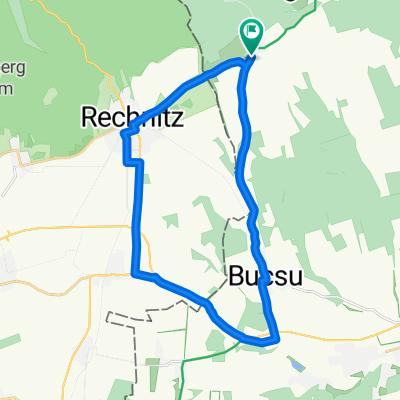
Other popular routes starting in Kőszeg
 VELOREGIO_15
- Distance
- 50.2 km
- Ascent
- 255 m
- Descent
- 254 m
- Location
- Kőszeg, Vas, Hungary
 Bringahorda 2018 opt1.3
- Distance
- 170.7 km
- Ascent
- 847 m
- Descent
- 847 m
- Location
- Kőszeg, Vas, Hungary
 Kőszeg-Szombathely
- Distance
- 59.4 km
- Ascent
- 240 m
- Descent
- 234 m
- Location
- Kőszeg, Vas, Hungary
 Kőszegi-hg_Hörmann-kör
- Distance
- 17 km
- Ascent
- 363 m
- Descent
- 363 m
- Location
- Kőszeg, Vas, Hungary
 VELOREGIO_08.
- Distance
- 23.9 km
- Ascent
- 134 m
- Descent
- 134 m
- Location
- Kőszeg, Vas, Hungary
 VELOREGIO_21
- Distance
- 112.9 km
- Ascent
- 276 m
- Descent
- 276 m
- Location
- Kőszeg, Vas, Hungary
 "Csúnya"-kör
- Distance
- 5.1 km
- Ascent
- 130 m
- Descent
- 130 m
- Location
- Kőszeg, Vas, Hungary
 Kőszeg-Velem-Cák
- Distance
- 44.2 km
- Ascent
- 720 m
- Descent
- 816 m
- Location
- Kőszeg, Vas, Hungary
Open it in the app