

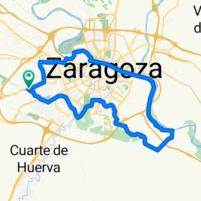
Zaragoza - Santuario Moncayo
A cycling route starting in Oliver-Valdefierro, Aragon, Spain.
Overview
About this route
- -:--
- Duration
- 112.3 km
- Distance
- 2,124 m
- Ascent
- 60 m
- Descent
- ---
- Avg. speed
- ---
- Avg. speed

Route quality
Waytypes & surfaces along the route
Waytypes
Track
51.3 km
(46 %)
Quiet road
25.9 km
(23 %)
Surfaces
Paved
13.1 km
(12 %)
Unpaved
25.3 km
(23 %)
Gravel
15.9 km
(14 %)
Unpaved (undefined)
9.2 km
(8 %)
Continue with Bikemap
Use, edit, or download this cycling route
You would like to ride Zaragoza - Santuario Moncayo or customize it for your own trip? Here is what you can do with this Bikemap route:
Free features
- Save this route as favorite or in collections
- Copy & plan your own version of this route
- Sync your route with Garmin or Wahoo
Premium features
Free trial for 3 days, or one-time payment. More about Bikemap Premium.
- Navigate this route on iOS & Android
- Export a GPX / KML file of this route
- Create your custom printout (try it for free)
- Download this route for offline navigation
Discover more Premium features.
Get Bikemap PremiumFrom our community
Other popular routes starting in Oliver-Valdefierro
 De Calle Ibón de Estanés 2, Zaragoza a Calle Ibón de Estanés 2, Zaragoza
- Distance
- 23.2 km
- Ascent
- 335 m
- Descent
- 316 m
- Location
- Oliver-Valdefierro, Aragon, Spain
 orilla canal hasta gravera garrapinillos
- Distance
- 12.8 km
- Ascent
- 17 m
- Descent
- 15 m
- Location
- Oliver-Valdefierro, Aragon, Spain
 Zaragoza - Epila - Bardallur - Zaragoza
- Distance
- 94.7 km
- Ascent
- 467 m
- Descent
- 448 m
- Location
- Oliver-Valdefierro, Aragon, Spain
 Miralbueno-Montañana
- Distance
- 42.8 km
- Ascent
- 164 m
- Descent
- 169 m
- Location
- Oliver-Valdefierro, Aragon, Spain
 Miralbueno - Ermita de Santa Bárbara
- Distance
- 5.5 km
- Ascent
- 35 m
- Descent
- 9 m
- Location
- Oliver-Valdefierro, Aragon, Spain
 miralbueno- trovador
- Distance
- 25.4 km
- Ascent
- 182 m
- Descent
- 191 m
- Location
- Oliver-Valdefierro, Aragon, Spain
 E7 : Zaragoza - Daroca
- Distance
- 101.3 km
- Ascent
- 851 m
- Descent
- 326 m
- Location
- Oliver-Valdefierro, Aragon, Spain
 Rosales-La cartuja-Rosales
- Distance
- 35.5 km
- Ascent
- 112 m
- Descent
- 110 m
- Location
- Oliver-Valdefierro, Aragon, Spain
Open it in the app