

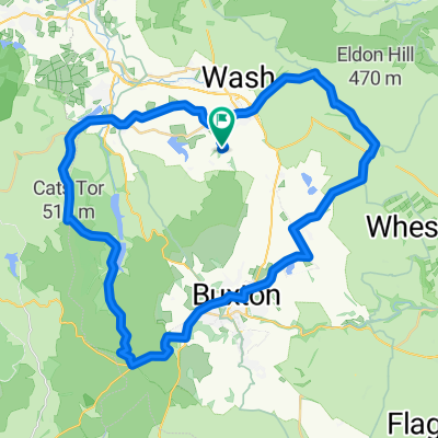
Peaks 92km round route
A cycling route starting in Chapel en le Frith, England, United Kingdom.
Overview
About this route
Chapel en le Frith - via
Chinley
Whaley Bridge
Macclesfield
Cat and Fiddle
Buxton
Bakewell
Baslow
Claver
Chapel en le Frith
- -:--
- Duration
- 92.5 km
- Distance
- 1,047 m
- Ascent
- 1,047 m
- Descent
- ---
- Avg. speed
- ---
- Avg. speed
Continue with Bikemap
Use, edit, or download this cycling route
You would like to ride Peaks 92km round route or customize it for your own trip? Here is what you can do with this Bikemap route:
Free features
- Save this route as favorite or in collections
- Copy & plan your own version of this route
- Sync your route with Garmin or Wahoo
Premium features
Free trial for 3 days, or one-time payment. More about Bikemap Premium.
- Navigate this route on iOS & Android
- Export a GPX / KML file of this route
- Create your custom printout (try it for free)
- Download this route for offline navigation
Discover more Premium features.
Get Bikemap PremiumFrom our community
Other popular routes starting in Chapel en le Frith
 Chapel-en-le-Frith to Chapel-en-le-Frith
- Distance
- 45.1 km
- Ascent
- 802 m
- Descent
- 803 m
- Location
- Chapel en le Frith, England, United Kingdom
 Combs Head near Chapel-en-le-Frith
- Distance
- 1.1 km
- Ascent
- 110 m
- Descent
- 0 m
- Location
- Chapel en le Frith, England, United Kingdom
 Tour of the Peak, 24 Oct 2009
- Distance
- 156.5 km
- Ascent
- 1,798 m
- Descent
- 1,798 m
- Location
- Chapel en le Frith, England, United Kingdom
 Chapel en le Frith 90km loop
- Distance
- 90.4 km
- Ascent
- 932 m
- Descent
- 943 m
- Location
- Chapel en le Frith, England, United Kingdom
 hathersage without monsal trail
- Distance
- 68.6 km
- Ascent
- 1,230 m
- Descent
- 1,231 m
- Location
- Chapel en le Frith, England, United Kingdom
 Keeper’s Cottage Loop
- Distance
- 29.4 km
- Ascent
- 622 m
- Descent
- 620 m
- Location
- Chapel en le Frith, England, United Kingdom
 High Moors and Gritstone Tors
- Distance
- 45.1 km
- Ascent
- 786 m
- Descent
- 787 m
- Location
- Chapel en le Frith, England, United Kingdom
 peak district dams
- Distance
- 62.9 km
- Ascent
- 773 m
- Descent
- 782 m
- Location
- Chapel en le Frith, England, United Kingdom
Open it in the app