
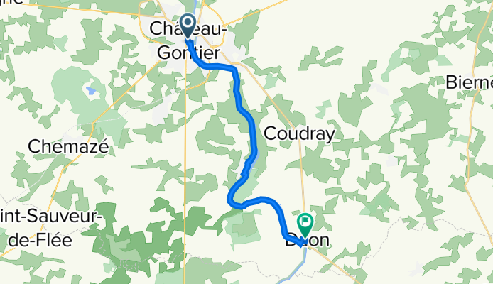
De Château-Gontier-sur-Mayenne à Rue du Tourniquet 2, Daon
A cycling route starting in Château-Gontier, Pays de la Loire Region, France.
Overview
About this route
- 52 min
- Duration
- 13.7 km
- Distance
- 106 m
- Ascent
- 132 m
- Descent
- 15.8 km/h
- Avg. speed
- 56 m
- Avg. speed

Route quality
Waytypes & surfaces along the route
Waytypes
Path
9.7 km
(71 %)
Quiet road
1.3 km
(10 %)
Surfaces
Paved
0.6 km
(4 %)
Unpaved
9.8 km
(72 %)
Gravel
9.8 km
(71 %)
Asphalt
0.4 km
(3 %)
Continue with Bikemap
Use, edit, or download this cycling route
You would like to ride De Château-Gontier-sur-Mayenne à Rue du Tourniquet 2, Daon or customize it for your own trip? Here is what you can do with this Bikemap route:
Free features
- Save this route as favorite or in collections
- Copy & plan your own version of this route
- Sync your route with Garmin or Wahoo
Premium features
Free trial for 3 days, or one-time payment. More about Bikemap Premium.
- Navigate this route on iOS & Android
- Export a GPX / KML file of this route
- Create your custom printout (try it for free)
- Download this route for offline navigation
Discover more Premium features.
Get Bikemap PremiumFrom our community
Other popular routes starting in Château-Gontier
 Château-Gontier-Le Lion d'Angers
- Distance
- 34.4 km
- Ascent
- 111 m
- Descent
- 115 m
- Location
- Château-Gontier, Pays de la Loire Region, France
 boucle saint fort
- Distance
- 14.1 km
- Ascent
- 99 m
- Descent
- 104 m
- Location
- Château-Gontier, Pays de la Loire Region, France
 Recovered Route
- Distance
- 48.4 km
- Ascent
- 29 m
- Descent
- 43 m
- Location
- Château-Gontier, Pays de la Loire Region, France
 21 Rue du 8 Mai 1945, Château-Gontier to 2 Rue Maryse Bastié, Château-Gontier
- Distance
- 4 km
- Ascent
- 55 m
- Descent
- 52 m
- Location
- Château-Gontier, Pays de la Loire Region, France
 Slow ride in Fromentières
- Distance
- 18.1 km
- Ascent
- 78 m
- Descent
- 105 m
- Location
- Château-Gontier, Pays de la Loire Region, France
 Mayenne 3: Chateau Gontier - Le Rossay
- Distance
- 45.8 km
- Ascent
- 319 m
- Descent
- 308 m
- Location
- Château-Gontier, Pays de la Loire Region, France
 Recovered Route
- Distance
- 29.6 km
- Ascent
- 26 m
- Descent
- 22 m
- Location
- Château-Gontier, Pays de la Loire Region, France
 Châteaux Gonthier Moulay
- Distance
- 65.5 km
- Ascent
- 485 m
- Descent
- 417 m
- Location
- Château-Gontier, Pays de la Loire Region, France
Open it in the app