
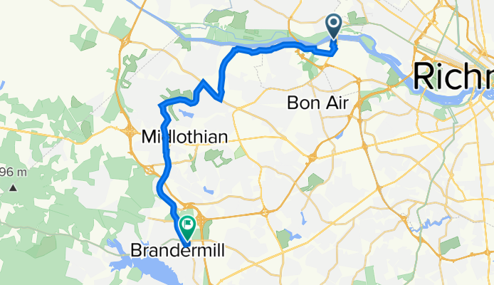
4701–4799 Southampton Rd, Richmond to 3007 E Boundary Terr, Midlothian
A cycling route starting in Tuckahoe, Virginia, United States of America.
Overview
About this route
- 1 h 34 min
- Duration
- 25 km
- Distance
- 236 m
- Ascent
- 200 m
- Descent
- 16 km/h
- Avg. speed
- 125 m
- Avg. speed
Route quality
Waytypes & surfaces along the route
Waytypes
Road
13.7 km
(55 %)
Busy road
10.3 km
(41 %)
Surfaces
Paved
18 km
(72 %)
Asphalt
18 km
(72 %)
Undefined
7 km
(28 %)
Continue with Bikemap
Use, edit, or download this cycling route
You would like to ride 4701–4799 Southampton Rd, Richmond to 3007 E Boundary Terr, Midlothian or customize it for your own trip? Here is what you can do with this Bikemap route:
Free features
- Save this route as favorite or in collections
- Copy & plan your own version of this route
- Sync your route with Garmin or Wahoo
Premium features
Free trial for 3 days, or one-time payment. More about Bikemap Premium.
- Navigate this route on iOS & Android
- Export a GPX / KML file of this route
- Create your custom printout (try it for free)
- Download this route for offline navigation
Discover more Premium features.
Get Bikemap PremiumFrom our community
Other popular routes starting in Tuckahoe
 Grove Ave, Richmond to Grove Ave, Richmond
- Distance
- 36.5 km
- Ascent
- 326 m
- Descent
- 328 m
- Location
- Tuckahoe, Virginia, United States of America
 Riverside
- Distance
- 30.2 km
- Ascent
- 216 m
- Descent
- 214 m
- Location
- Tuckahoe, Virginia, United States of America
 7708 Hollins Rd to Academic Learning Commons - VCU
- Distance
- 21.7 km
- Ascent
- 74 m
- Descent
- 74 m
- Location
- Tuckahoe, Virginia, United States of America
 Route 1 From Home
- Distance
- 21.5 km
- Ascent
- 172 m
- Descent
- 175 m
- Location
- Tuckahoe, Virginia, United States of America
 Bike Route - Hug. Flatwater
- Distance
- 6.3 km
- Ascent
- 43 m
- Descent
- 90 m
- Location
- Tuckahoe, Virginia, United States of America
 6601 Park Ave, Richmond to 11760 N Lakeridge Pkwy, Ashland
- Distance
- 21.3 km
- Ascent
- 20 m
- Descent
- 40 m
- Location
- Tuckahoe, Virginia, United States of America
 Test Loop
- Distance
- 0.9 km
- Ascent
- 9 m
- Descent
- 10 m
- Location
- Tuckahoe, Virginia, United States of America
 Riverside Reversed
- Distance
- 30.2 km
- Ascent
- 224 m
- Descent
- 226 m
- Location
- Tuckahoe, Virginia, United States of America
Open it in the app