

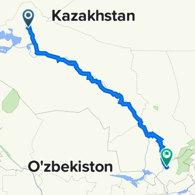
Trasa z Aral (Арал) do Taszkent (Toshkent)
A cycling route starting in Aral, Qyzylorda Oblysy, Kazakhstan.
Overview
About this route
File with points/tracks from Locus Map/4.12.2
- 64 h 42 min
- Duration
- 1,109 km
- Distance
- 1,588 m
- Ascent
- 1,199 m
- Descent
- 17.1 km/h
- Avg. speed
- 558 m
- Avg. speed
Route quality
Waytypes & surfaces along the route
Waytypes
Road
323.4 km
(29 %)
Quiet road
293.9 km
(27 %)
Surfaces
Paved
347.5 km
(31 %)
Unpaved
118.4 km
(11 %)
Asphalt
347.5 km
(31 %)
Unpaved (undefined)
65.2 km
(6 %)
Continue with Bikemap
Use, edit, or download this cycling route
You would like to ride Trasa z Aral (Арал) do Taszkent (Toshkent) or customize it for your own trip? Here is what you can do with this Bikemap route:
Free features
- Save this route as favorite or in collections
- Copy & plan your own version of this route
- Sync your route with Garmin or Wahoo
Premium features
Free trial for 3 days, or one-time payment. More about Bikemap Premium.
- Navigate this route on iOS & Android
- Export a GPX / KML file of this route
- Create your custom printout (try it for free)
- Download this route for offline navigation
Discover more Premium features.
Get Bikemap PremiumFrom our community
Other popular routes starting in Aral
 17-30
17-30- Distance
- 4.9 km
- Ascent
- 3 m
- Descent
- 12 m
- Location
- Aral, Qyzylorda Oblysy, Kazakhstan
 Aral Cycling
- Distance
- 150.1 km
- Ascent
- 411 m
- Descent
- 376 m
- Location
- Aral, Qyzylorda Oblysy, Kazakhstan
 Trasa z Aral (Арал) do Taszkent (Toshkent)
- Distance
- 1,109 km
- Ascent
- 1,588 m
- Descent
- 1,199 m
- Location
- Aral, Qyzylorda Oblysy, Kazakhstan
 Aral vers Mongolie
- Distance
- 7,204.5 km
- Ascent
- 10,999 m
- Descent
- 9,646 m
- Location
- Aral, Qyzylorda Oblysy, Kazakhstan
Open it in the app