Premium Badge Download on the App Store Get it on Google Play Turn-by-turn Navigation Offline Maps Bike Type Optimized Routing Premium Maps Custom Bike Computer Export Routes Route Previews Fall Detection Premium Support

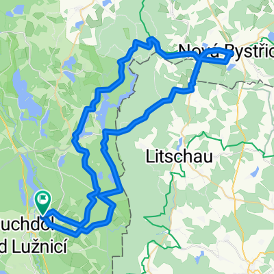
Cycling Route in Suchdol nad Lužnicí, Jihočeský kraj, Czechia

Třeboňsko 02

1
Open this route in the Bikemap app

Open this route in the Bikemap app

Open this route in Bikemap Web

Open this route in Bikemap Web

63 km
Distance
346 m
Ascent
346 m
Descent
-:-- h
Duration
-- km/h
Avg. Speed
--- m
Max. Elevation

About This Route

7.7.2006

SUCHDOL n.LUŽ. - KLIKOV – FRANTIŠKOV – STAŇKOV – PERŠLÁK – NOVÁ BYSTŘICE – STAŇKOV - SUCHDOL n.LUŽ.<br /><br />Suchdol n Luž. – po silnici 1012 – Klikov – Františkov – doleva po červené lesem – Nová Huť – lesem – Medenice u Staňkova – odbočka 1005 – rašeliniště Pele – hledání hráze – podél Staňkova – po hrázi – Staňkov – občerstvení - po modré – Markétské polesí – Smírčí vrch – Chlumecká cesta – po 322 doprava – Peršlák – po silnici – 32 – stoupání - sjezd do Nové Bystřice – oběd - pohraniční policie – golf – bývalá signálka 1007 - sjezd - Peršlák – lesem – po silnici 322 – asfalt – Staňkov - po 322 – Hamr – odbočka vpravo 1011 – lesem – Klikov -<br />Suchdol n. Luž.

This cycling route is ideal for: MTB

You will cycle on the following surfaces: Paved Unpaved Gravel

Customize this cycling route with the Bikemap route planner.

Make it yours!

Did you know? You can use this route as a template in our cycling route planner if you don't wish to start from scratch. Customize it based on your needs to plan your perfect cycling tour.

Open it in the app