

Point Arkwright to The Boatshed, Cotton Tree
A cycling route starting in Coolum Beach, Queensland, Australia.
Overview
About this route
- -:--
- Duration
- 41.4 km
- Distance
- 112 m
- Ascent
- 112 m
- Descent
- ---
- Avg. speed
- 24 m
- Avg. speed

Route quality
Waytypes & surfaces along the route
Waytypes
Cycleway
36 km
(87 %)
Path
1.5 km
(4 %)
Surfaces
Paved
32.9 km
(80 %)
Unpaved
0.2 km
(<1 %)
Concrete
28.9 km
(70 %)
Asphalt
2.7 km
(7 %)
Route highlights
Points of interest along the route

Point of interest after 0.9 km
The entry point from the Yerranya Row.

Point of interest after 1.1 km
The Coastal Pathway goes through Birrahl Park and goes onto Yerrany Row (a street) on the other side.

Point of interest after 2.5 km
At this point you can cross the David Low Way and head up Tanah Street West to Mount Coolum. It takes about 45 minutes to climb up and 30 minutes to come down. Check out this link: https://www.visitsunshinecoast.com/guide/climb-mount-coolum

Point of interest after 2.5 km
Turn left into Jarnahill Drive to go into the carpark at the base of the mountain.

Point of interest after 3.5 km
Curly's on the Boardwalk is an awesome cafe, good food and great service.

Point of interest after 3.5 km
Take this turn off to go onto the boardwalk and head out east to the lookout. Awesome views!

Point of interest after 16.6 km
This is a sharp left turn to go onto the path which goes across the bridge.

Point of interest after 25.4 km
Cross over the road here to access the path across the Maroochy River Bridge.

Point of interest after 32.4 km
It's a nice little path.

Point of interest after 32.6 km
Cottonwood Road might end here but the path goes through!
Continue with Bikemap
Use, edit, or download this cycling route
You would like to ride Point Arkwright to The Boatshed, Cotton Tree or customize it for your own trip? Here is what you can do with this Bikemap route:
Free features
- Save this route as favorite or in collections
- Copy & plan your own version of this route
- Sync your route with Garmin or Wahoo
Premium features
Free trial for 3 days, or one-time payment. More about Bikemap Premium.
- Navigate this route on iOS & Android
- Export a GPX / KML file of this route
- Create your custom printout (try it for free)
- Download this route for offline navigation
Discover more Premium features.
Get Bikemap PremiumFrom our community
Other popular routes starting in Coolum Beach
 1–7 Margaret Street, Coolum Beach to 1838-1842 David Low Way, Coolum Beach
- Distance
- 27.4 km
- Ascent
- 95 m
- Descent
- 96 m
- Location
- Coolum Beach, Queensland, Australia
 39 Tradewinds Ave, Coolum Beach to 39 Tradewinds Ave, Coolum Beach
- Distance
- 7 km
- Ascent
- 18 m
- Descent
- 17 m
- Location
- Coolum Beach, Queensland, Australia
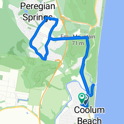 Peregian springs
- Distance
- 14 km
- Ascent
- 81 m
- Descent
- 82 m
- Location
- Coolum Beach, Queensland, Australia
 Mount coolum to 101 Wrigley street Maroochydore
- Distance
- 7.1 km
- Ascent
- 16 m
- Descent
- 35 m
- Location
- Coolum Beach, Queensland, Australia
 Suneshine Coast
- Distance
- 58.1 km
- Ascent
- 67 m
- Descent
- 74 m
- Location
- Coolum Beach, Queensland, Australia
 Noosa loop walk 42.7km
- Distance
- 43.5 km
- Ascent
- 308 m
- Descent
- 308 m
- Location
- Coolum Beach, Queensland, Australia
 Family-Friendly E-Bike Journey from Coolum Beach to Cotton Tree
- Distance
- 48 km
- Ascent
- 192 m
- Descent
- 192 m
- Location
- Coolum Beach, Queensland, Australia
 Easy ride in Coolum Beach
- Distance
- 12.6 km
- Ascent
- 96 m
- Descent
- 103 m
- Location
- Coolum Beach, Queensland, Australia
Open it in the app