
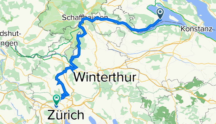
Bodensee-Zurich
A cycling route starting in Gaienhofen, Baden-Württemberg, Germany.
Overview
About this route
- -:--
- Duration
- 91.3 km
- Distance
- 1,002 m
- Ascent
- 901 m
- Descent
- ---
- Avg. speed
- 540 m
- Avg. speed
Route quality
Waytypes & surfaces along the route
Waytypes
Quiet road
28.9 km
(32 %)
Track
20.1 km
(22 %)
Surfaces
Paved
80.9 km
(89 %)
Unpaved
9.5 km
(10 %)
Asphalt
78.6 km
(86 %)
Gravel
7 km
(8 %)
Continue with Bikemap
Use, edit, or download this cycling route
You would like to ride Bodensee-Zurich or customize it for your own trip? Here is what you can do with this Bikemap route:
Free features
- Save this route as favorite or in collections
- Copy & plan your own version of this route
- Sync your route with Garmin or Wahoo
Premium features
Free trial for 3 days, or one-time payment. More about Bikemap Premium.
- Navigate this route on iOS & Android
- Export a GPX / KML file of this route
- Create your custom printout (try it for free)
- Download this route for offline navigation
Discover more Premium features.
Get Bikemap PremiumFrom our community
Other popular routes starting in Gaienhofen
 witthoh
- Distance
- 93.9 km
- Ascent
- 1,008 m
- Descent
- 1,019 m
- Location
- Gaienhofen, Baden-Württemberg, Germany
 Schienerberg und Seerücken
- Distance
- 86.1 km
- Ascent
- 1,447 m
- Descent
- 1,341 m
- Location
- Gaienhofen, Baden-Württemberg, Germany
 Höri 2
- Distance
- 31.5 km
- Ascent
- 496 m
- Descent
- 512 m
- Location
- Gaienhofen, Baden-Württemberg, Germany
 7 Von Gaienhofen bis Feuerthalen
- Distance
- 32.2 km
- Ascent
- 338 m
- Descent
- 313 m
- Location
- Gaienhofen, Baden-Württemberg, Germany
 Bodensee 72
- Distance
- 71.2 km
- Ascent
- 246 m
- Descent
- 246 m
- Location
- Gaienhofen, Baden-Württemberg, Germany
 Höri 1
- Distance
- 31.7 km
- Ascent
- 447 m
- Descent
- 463 m
- Location
- Gaienhofen, Baden-Württemberg, Germany
 Bodenseeumrundung ab Horn
- Distance
- 194.9 km
- Ascent
- 543 m
- Descent
- 574 m
- Location
- Gaienhofen, Baden-Württemberg, Germany
 4 Friends
- Distance
- 62.9 km
- Ascent
- 304 m
- Descent
- 257 m
- Location
- Gaienhofen, Baden-Württemberg, Germany
Open it in the app