
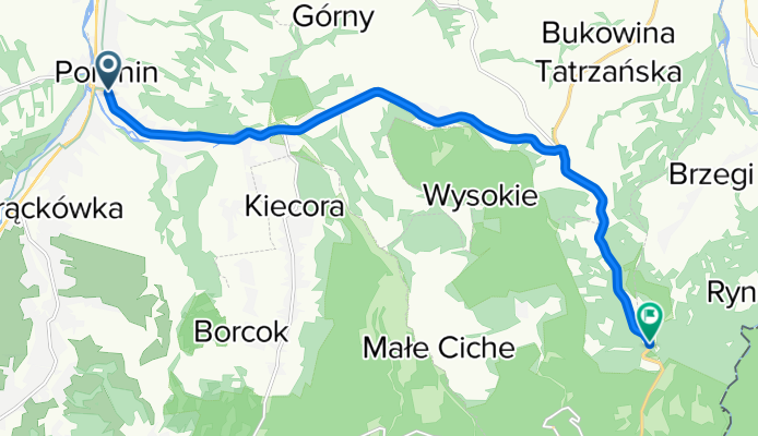
GLODOWKA, por Poronin
A cycling route starting in Poronin, Lesser Poland Voivodeship, Poland.
Overview
About this route
Subida.
- -:--
- Duration
- 10.9 km
- Distance
- 426 m
- Ascent
- 27 m
- Descent
- ---
- Avg. speed
- 1,140 m
- Avg. speed

Route quality
Waytypes & surfaces along the route
Waytypes
Busy road
10.7 km
(98 %)
Quiet road
0.1 km
(1 %)
Access road
0.1 km
(<1 %)
Surfaces
Paved
10.7 km
(98 %)
Asphalt
10.7 km
(98 %)
Undefined
0.2 km
(2 %)
Continue with Bikemap
Use, edit, or download this cycling route
You would like to ride GLODOWKA, por Poronin or customize it for your own trip? Here is what you can do with this Bikemap route:
Free features
- Save this route as favorite or in collections
- Copy & plan your own version of this route
- Sync your route with Garmin or Wahoo
Premium features
Free trial for 3 days, or one-time payment. More about Bikemap Premium.
- Navigate this route on iOS & Android
- Export a GPX / KML file of this route
- Create your custom printout (try it for free)
- Download this route for offline navigation
Discover more Premium features.
Get Bikemap PremiumFrom our community
Other popular routes starting in Poronin
 Rusiński Wierch + Dolina Białej wody + Zgorzelisko
- Distance
- 51.2 km
- Ascent
- 779 m
- Descent
- 779 m
- Location
- Poronin, Lesser Poland Voivodeship, Poland
 Chata nad Zielonym Stawem + okoliczne górki i przełęcze
- Distance
- 140.1 km
- Ascent
- 2,300 m
- Descent
- 2,298 m
- Location
- Poronin, Lesser Poland Voivodeship, Poland
 ZAKOPANE 2011: Zakopane Harenda-Poronin-Bukowina Tatrzanska-Lysa Polana-Tatrzanska Javorina-Jurgow-Rzepiska-Bukowina-Poronin-Harenda
- Distance
- 52.6 km
- Ascent
- 797 m
- Descent
- 797 m
- Location
- Poronin, Lesser Poland Voivodeship, Poland
 ZAKOPANE 2011: Zakopane - Poronin - Bukowina Tatrzanska - Czarna Góra - Niedzica - Szaflary - Biały Dunajec - Ząb - Zakopane
- Distance
- 102.1 km
- Ascent
- 1,234 m
- Descent
- 1,234 m
- Location
- Poronin, Lesser Poland Voivodeship, Poland
 N.TARG - RAJCZA (Zuberec/Vlasky/Malatina/Zazriva) 2dni
- Distance
- 189.2 km
- Ascent
- 2,014 m
- Descent
- 2,242 m
- Location
- Poronin, Lesser Poland Voivodeship, Poland
 Poronin-Hrube-Łysa Polana - OSTURNA-Łapszanka-Brzegi-Poronin
- Distance
- 63.5 km
- Ascent
- 1,218 m
- Descent
- 1,218 m
- Location
- Poronin, Lesser Poland Voivodeship, Poland
 Pętla - Harenda - Rafaczowki - Gubalowka - Dzianisz - Witow - Koscielisko - Zakopane - Harenda
- Distance
- 34.5 km
- Ascent
- 573 m
- Descent
- 576 m
- Location
- Poronin, Lesser Poland Voivodeship, Poland
 Poronin-Hrube-Rondo-Termy-Poronin
- Distance
- 32.1 km
- Ascent
- 601 m
- Descent
- 601 m
- Location
- Poronin, Lesser Poland Voivodeship, Poland
Open it in the app