

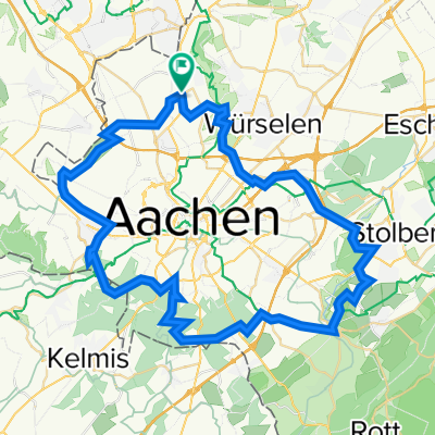
Radeln für die Seele. Aachen A
A cycling route starting in Würselen, North Rhine-Westphalia, Germany.
Overview
About this route
- -:--
- Duration
- 40.4 km
- Distance
- 486 m
- Ascent
- 486 m
- Descent
- ---
- Avg. speed
- 239 m
- Max. altitude
Route quality
Waytypes & surfaces along the route
Waytypes
Quiet road
20.2 km
(50 %)
Road
8.1 km
(20 %)
Surfaces
Paved
28.7 km
(71 %)
Unpaved
5.3 km
(13 %)
Asphalt
28.7 km
(71 %)
Ground
2.4 km
(6 %)
Route highlights
Points of interest along the route
Point of interest after 2.3 km
NL
Point of interest after 4.1 km
DE
Point of interest after 4.7 km
Haus Heyden Wasserburg
Point of interest after 9.2 km
Avantism Kiting Area
Point of interest after 9.2 km
NL
Point of interest after 11.3 km
Hoeve Scholtissenhof
Point of interest after 14.5 km
Lemiers
Point of interest after 17.7 km
Bilderberg Kasteel Vaalsbroek
Point of interest after 20.2 km
Schloss Blumenthal
Point of interest after 24.1 km
Aachener Westfriedhof
Point of interest after 30.6 km
Soers / CHIO
Point of interest after 33.6 km
Wurmtal
Continue with Bikemap
Use, edit, or download this cycling route
You would like to ride Radeln für die Seele. Aachen A or customize it for your own trip? Here is what you can do with this Bikemap route:
Free features
- Save this route as favorite or in collections
- Copy & plan your own version of this route
- Sync your route with Garmin or Wahoo
Premium features
Free trial for 3 days, or one-time payment. More about Bikemap Premium.
- Navigate this route on iOS & Android
- Export a GPX / KML file of this route
- Create your custom printout (try it for free)
- Download this route for offline navigation
Discover more Premium features.
Get Bikemap PremiumFrom our community
Other popular routes starting in Würselen
 Aachener Runde
- Distance
- 58 km
- Ascent
- 765 m
- Descent
- 766 m
- Location
- Würselen, North Rhine-Westphalia, Germany
 Tini-Tour
- Distance
- 59.7 km
- Ascent
- 451 m
- Descent
- 464 m
- Location
- Würselen, North Rhine-Westphalia, Germany
 Tagebau Inden und Blausteinsee
- Distance
- 50.4 km
- Ascent
- 211 m
- Descent
- 211 m
- Location
- Würselen, North Rhine-Westphalia, Germany
 Linden-Neusen - Stolber/Atsch - Linden-Neusen
- Distance
- 19.7 km
- Ascent
- 96 m
- Descent
- 97 m
- Location
- Würselen, North Rhine-Westphalia, Germany
 Die Würselen, Blausteinsee, Stolberg, Lammersdorf, Konzen, Rötgen, Lichtenbusch, Eilendorf und zu
- Distance
- 109.5 km
- Ascent
- 866 m
- Descent
- 882 m
- Location
- Würselen, North Rhine-Westphalia, Germany
 Kleine Wurmrunde
- Distance
- 18.4 km
- Ascent
- 315 m
- Descent
- 315 m
- Location
- Würselen, North Rhine-Westphalia, Germany
 Brander Wald
- Distance
- 29.6 km
- Ascent
- 145 m
- Descent
- 150 m
- Location
- Würselen, North Rhine-Westphalia, Germany
 Mergellandtour vom 23.02.08
- Distance
- 81 km
- Ascent
- 838 m
- Descent
- 859 m
- Location
- Würselen, North Rhine-Westphalia, Germany
Open it in the app