

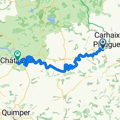
105 Kerantre, Le Moustoir à 3 Place de la Mairie, Landeleau
A cycling route starting in Carhaix-Plouguer, Brittany Region, France.
Overview
About this route
- 1 h 35 min
- Duration
- 24.1 km
- Distance
- 307 m
- Ascent
- 329 m
- Descent
- 15.2 km/h
- Avg. speed
- 128 m
- Avg. speed

Route quality
Waytypes & surfaces along the route
Waytypes
Path
18.3 km
(76 %)
Quiet road
3.1 km
(13 %)
Surfaces
Paved
9.4 km
(39 %)
Unpaved
6.7 km
(28 %)
Asphalt
9.3 km
(39 %)
Unpaved (undefined)
5.7 km
(24 %)
Continue with Bikemap
Use, edit, or download this cycling route
You would like to ride 105 Kerantre, Le Moustoir à 3 Place de la Mairie, Landeleau or customize it for your own trip? Here is what you can do with this Bikemap route:
Free features
- Save this route as favorite or in collections
- Copy & plan your own version of this route
- Sync your route with Garmin or Wahoo
Premium features
Free trial for 3 days, or one-time payment. More about Bikemap Premium.
- Navigate this route on iOS & Android
- Export a GPX / KML file of this route
- Create your custom printout (try it for free)
- Download this route for offline navigation
Discover more Premium features.
Get Bikemap PremiumFrom our community
Other popular routes starting in Carhaix-Plouguer
 Carhaix-Plouquer - Rostrenen
- Distance
- 32.7 km
- Ascent
- 175 m
- Descent
- 141 m
- Location
- Carhaix-Plouguer, Brittany Region, France
 Carhaix a Pontivy
- Distance
- 85.3 km
- Ascent
- 225 m
- Descent
- 300 m
- Location
- Carhaix-Plouguer, Brittany Region, France
 carhaix chateaulin
- Distance
- 73.8 km
- Ascent
- 124 m
- Descent
- 195 m
- Location
- Carhaix-Plouguer, Brittany Region, France
 11 Carhaix - Locronan
- Distance
- 96 km
- Ascent
- 800 m
- Descent
- 853 m
- Location
- Carhaix-Plouguer, Brittany Region, France
 Tour de France 2011, part 5
- Distance
- 166.8 km
- Ascent
- 924 m
- Descent
- 998 m
- Location
- Carhaix-Plouguer, Brittany Region, France
 03 - Carhaix / Rostrenen
- Distance
- 32.8 km
- Ascent
- 211 m
- Descent
- 178 m
- Location
- Carhaix-Plouguer, Brittany Region, France
 Carhaix-Pontivy on Canal
- Distance
- 75.6 km
- Ascent
- 250 m
- Descent
- 295 m
- Location
- Carhaix-Plouguer, Brittany Region, France
 Day 2 Wednesday 15 May 92 km
- Distance
- 91.9 km
- Ascent
- 504 m
- Descent
- 612 m
- Location
- Carhaix-Plouguer, Brittany Region, France
Open it in the app