

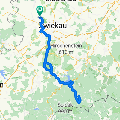
Dänkritzer Straße, Zwickau nach Randsiedlung 11, Werdau
A cycling route starting in Hartmannsdorf, Saxony, Germany.
Overview
About this route
- 42 min
- Duration
- 5.4 km
- Distance
- 34 m
- Ascent
- 58 m
- Descent
- 7.8 km/h
- Avg. speed
- 387 m
- Avg. speed
Route quality
Waytypes & surfaces along the route
Waytypes
Track
3.2 km
(58 %)
Quiet road
0.7 km
(13 %)
Surfaces
Paved
1.5 km
(28 %)
Unpaved
3.4 km
(62 %)
Unpaved (undefined)
1.6 km
(30 %)
Ground
1.4 km
(26 %)
Continue with Bikemap
Use, edit, or download this cycling route
You would like to ride Dänkritzer Straße, Zwickau nach Randsiedlung 11, Werdau or customize it for your own trip? Here is what you can do with this Bikemap route:
Free features
- Save this route as favorite or in collections
- Copy & plan your own version of this route
- Sync your route with Garmin or Wahoo
Premium features
Free trial for 3 days, or one-time payment. More about Bikemap Premium.
- Navigate this route on iOS & Android
- Export a GPX / KML file of this route
- Create your custom printout (try it for free)
- Download this route for offline navigation
Discover more Premium features.
Get Bikemap PremiumFrom our community
Other popular routes starting in Hartmannsdorf
 Bachweg 66, Zwickau nach Bachweg 40, Zwickau
- Distance
- 36.5 km
- Ascent
- 354 m
- Descent
- 336 m
- Location
- Hartmannsdorf, Saxony, Germany
 Königswalde b.Werdau z. Auersberg
- Distance
- 119.3 km
- Ascent
- 1,702 m
- Descent
- 1,618 m
- Location
- Hartmannsdorf, Saxony, Germany
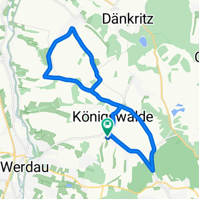 Königswalde
- Distance
- 13.6 km
- Ascent
- 122 m
- Descent
- 121 m
- Location
- Hartmannsdorf, Saxony, Germany
 An den Linden, Werdau nach Niederhohndorfer Querweg 18D, Zwickau
- Distance
- 23.1 km
- Ascent
- 256 m
- Descent
- 254 m
- Location
- Hartmannsdorf, Saxony, Germany
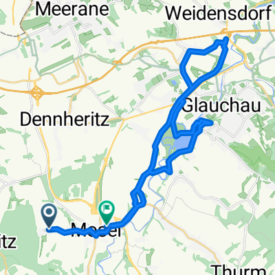 Bachweg 66, Zwickau nach Schlunziger Straße 8, Zwickau
- Distance
- 25.3 km
- Ascent
- 101 m
- Descent
- 131 m
- Location
- Hartmannsdorf, Saxony, Germany
 Arbeit
- Distance
- 6.3 km
- Ascent
- 39 m
- Descent
- 85 m
- Location
- Hartmannsdorf, Saxony, Germany
 Kober-Runde
- Distance
- 35.8 km
- Ascent
- 236 m
- Descent
- 333 m
- Location
- Hartmannsdorf, Saxony, Germany
 Am Steinberg 7, Neukirchen/Pleiße nach Dänkritzer Straße, Neukirchen/Pleiße
- Distance
- 17.8 km
- Ascent
- 203 m
- Descent
- 268 m
- Location
- Hartmannsdorf, Saxony, Germany
Open it in the app