
forca rossa
A cycling route starting in Alleghe, Veneto, Italy.
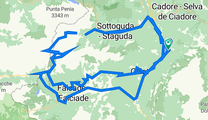
Overview
About this route
- 21 h 24 min
- Duration
- 121.3 km
- Distance
- 7,152 m
- Ascent
- 7,154 m
- Descent
- 5.7 km/h
- Avg. speed
- 2,859 m
- Avg. speed

Continue with Bikemap
Use, edit, or download this cycling route
You would like to ride forca rossa or customize it for your own trip? Here is what you can do with this Bikemap route:
Free features
- Save this route as favorite or in collections
- Copy & plan your own version of this route
- Sync your route with Garmin or Wahoo
Premium features
Free trial for 3 days, or one-time payment. More about Bikemap Premium.
- Navigate this route on iOS & Android
- Export a GPX / KML file of this route
- Create your custom printout (try it for free)
- Download this route for offline navigation
Discover more Premium features.
Get Bikemap PremiumFrom our community
Other popular routes starting in Alleghe
 5. a) etappe, 14. mai, Alleghe til Belluno (Road bike 50 km)
- Distance
- 50.3 km
- Ascent
- 1,116 m
- Descent
- 1,701 m
- Location
- Alleghe, Veneto, Italy
 Alleghe - Gares
- Distance
- 36.7 km
- Ascent
- 720 m
- Descent
- 720 m
- Location
- Alleghe, Veneto, Italy
 Alleghe - Col dei Baldi
- Distance
- 20.8 km
- Ascent
- 999 m
- Descent
- 992 m
- Location
- Alleghe, Veneto, Italy
 5. b) etappe, 14. mai, Alleghe til Belluno. (E-bike 71 km)
- Distance
- 70.6 km
- Ascent
- 1,907 m
- Descent
- 2,492 m
- Location
- Alleghe, Veneto, Italy
 Tour de Civetta - Passo Staulanza, Duran
- Distance
- 70.4 km
- Ascent
- 1,723 m
- Descent
- 1,728 m
- Location
- Alleghe, Veneto, Italy
 Alleghe-Agordo-Passo Duran-Passo Staulanzo-Alleghe
- Distance
- 77 km
- Ascent
- 2,609 m
- Descent
- 2,611 m
- Location
- Alleghe, Veneto, Italy
 Alleghe - Falcade
- Distance
- 30.8 km
- Ascent
- 541 m
- Descent
- 541 m
- Location
- Alleghe, Veneto, Italy
 Molto in Alto 2016 - 1b
- Distance
- 70.2 km
- Ascent
- 1,747 m
- Descent
- 1,747 m
- Location
- Alleghe, Veneto, Italy
Open it in the app