

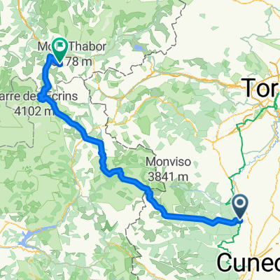
Castiglione Saluzzo-Torino
A cycling route starting in Costigliole Saluzzo, Piedmont, Italy.
Overview
About this route
- -:--
- Duration
- 79.8 km
- Distance
- 182 m
- Ascent
- 411 m
- Descent
- ---
- Avg. speed
- 456 m
- Avg. speed
Route quality
Waytypes & surfaces along the route
Waytypes
Quiet road
32.1 km
(40 %)
Cycleway
27.2 km
(34 %)
Surfaces
Paved
40.7 km
(51 %)
Unpaved
5.3 km
(7 %)
Asphalt
39 km
(49 %)
Gravel
3.7 km
(5 %)
Continue with Bikemap
Use, edit, or download this cycling route
You would like to ride Castiglione Saluzzo-Torino or customize it for your own trip? Here is what you can do with this Bikemap route:
Free features
- Save this route as favorite or in collections
- Copy & plan your own version of this route
- Sync your route with Garmin or Wahoo
Premium features
Free trial for 3 days, or one-time payment. More about Bikemap Premium.
- Navigate this route on iOS & Android
- Export a GPX / KML file of this route
- Create your custom printout (try it for free)
- Download this route for offline navigation
Discover more Premium features.
Get Bikemap PremiumFrom our community
Other popular routes starting in Costigliole Saluzzo
 Col Bonnette Tour
- Distance
- 320.7 km
- Ascent
- 6,571 m
- Descent
- 6,580 m
- Location
- Costigliole Saluzzo, Piedmont, Italy
 Costigliole Saluzzo-Valmeiner Station
- Distance
- 189.6 km
- Ascent
- 5,089 m
- Descent
- 3,682 m
- Location
- Costigliole Saluzzo, Piedmont, Italy
 1°luglio Valmala - strada dei cannoni - punta cavallo - colle del prete - colle gilba - monbracco
- Distance
- 158.3 km
- Ascent
- 4,634 m
- Descent
- 4,777 m
- Location
- Costigliole Saluzzo, Piedmont, Italy
 Fauniera da Esischie
- Distance
- 131.7 km
- Ascent
- 3,302 m
- Descent
- 3,300 m
- Location
- Costigliole Saluzzo, Piedmont, Italy
 westlicher Alpenbogen
- Distance
- 517.5 km
- Ascent
- 9,842 m
- Descent
- 9,842 m
- Location
- Costigliole Saluzzo, Piedmont, Italy
 COSTIGLIOLE SALUZZO, SAMPEYRE DA STROPPO, COLLE DELL'AGNELLO, COSTIGLIOLE
- Distance
- 163.5 km
- Ascent
- 3,543 m
- Descent
- 3,551 m
- Location
- Costigliole Saluzzo, Piedmont, Italy
 Costigliole Tour santuario Valmala
- Distance
- 46.6 km
- Ascent
- 995 m
- Descent
- 992 m
- Location
- Costigliole Saluzzo, Piedmont, Italy
 EuroVelo 8 - Ciclovia del Mediterraneo - parte Italia 3
- Distance
- 70.7 km
- Ascent
- 472 m
- Descent
- 249 m
- Location
- Costigliole Saluzzo, Piedmont, Italy
Open it in the app