

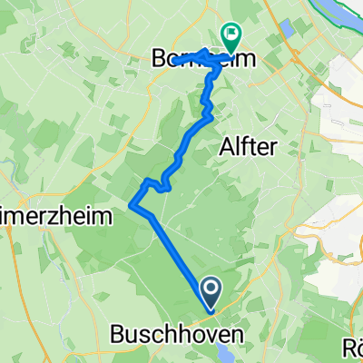
Von-den-Driesch-Straße 71, Bonn nach Weimarer Straße 28A, Bornheim
A cycling route starting in Alfter, North Rhine-Westphalia, Germany.
Overview
About this route
- 36 min
- Duration
- 10.3 km
- Distance
- 19 m
- Ascent
- 14 m
- Descent
- 17.3 km/h
- Avg. speed
- 68 m
- Avg. speed

Route quality
Waytypes & surfaces along the route
Waytypes
Track
7.3 km
(71 %)
Quiet road
2.8 km
(28 %)
Surfaces
Paved
10.3 km
(100 %)
Asphalt
8.7 km
(84 %)
Paved (undefined)
1.5 km
(15 %)
Continue with Bikemap
Use, edit, or download this cycling route
You would like to ride Von-den-Driesch-Straße 71, Bonn nach Weimarer Straße 28A, Bornheim or customize it for your own trip? Here is what you can do with this Bikemap route:
Free features
- Save this route as favorite or in collections
- Copy & plan your own version of this route
- Sync your route with Garmin or Wahoo
Premium features
Free trial for 3 days, or one-time payment. More about Bikemap Premium.
- Navigate this route on iOS & Android
- Export a GPX / KML file of this route
- Create your custom printout (try it for free)
- Download this route for offline navigation
Discover more Premium features.
Get Bikemap PremiumFrom our community
Other popular routes starting in Alfter
 RTF Alfter 2Pkt
- Distance
- 74.3 km
- Ascent
- 249 m
- Descent
- 268 m
- Location
- Alfter, North Rhine-Westphalia, Germany
 Kleine Tour von Alfter nach Hilberath
- Distance
- 52.5 km
- Ascent
- 417 m
- Descent
- 408 m
- Location
- Alfter, North Rhine-Westphalia, Germany
 Rund um Meckenheim
- Distance
- 35.4 km
- Ascent
- 198 m
- Descent
- 196 m
- Location
- Alfter, North Rhine-Westphalia, Germany
 BONN-Vischeltal (MTB)
- Distance
- 59.8 km
- Ascent
- 483 m
- Descent
- 483 m
- Location
- Alfter, North Rhine-Westphalia, Germany
 Vorgebirge /Rhein Teil 2
- Distance
- 51.5 km
- Ascent
- 290 m
- Descent
- 308 m
- Location
- Alfter, North Rhine-Westphalia, Germany
 Ausfahrt von Alfter nach Bornheim
- Distance
- 15.1 km
- Ascent
- 42 m
- Descent
- 169 m
- Location
- Alfter, North Rhine-Westphalia, Germany
 Kottenforst - Wachtberg Tour (07.05.2011)
- Distance
- 39.8 km
- Ascent
- 316 m
- Descent
- 316 m
- Location
- Alfter, North Rhine-Westphalia, Germany
![[DAY 35] Bonn - Hasenfeld (Eifel National Park)](https://media.bikemap.net/routes/8692564/gallery/thumbs/29c8ac98-a6a1-40d9-a0e0-8d127464530a.jpeg.208x208_q80_crop.jpg) [DAY 35] Bonn - Hasenfeld (Eifel National Park)
[DAY 35] Bonn - Hasenfeld (Eifel National Park)- Distance
- 59.1 km
- Ascent
- 524 m
- Descent
- 348 m
- Location
- Alfter, North Rhine-Westphalia, Germany
Open it in the app