
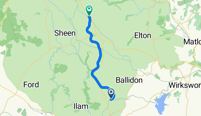
4 Station Cottage, Ashbourne to Pennine Bridleway, Parsley Hay, Buxton
A cycling route starting in Ashbourne, England, United Kingdom.
Overview
About this route
- 1 h 16 min
- Duration
- 15.1 km
- Distance
- 165 m
- Ascent
- 58 m
- Descent
- 11.9 km/h
- Avg. speed
- 349 m
- Avg. speed
Route quality
Waytypes & surfaces along the route
Waytypes
Cycleway
14.9 km
(98 %)
Pedestrian area
0.2 km
(<1 %)
Surfaces
Paved
0.1 km
(<1 %)
Unpaved
14.4 km
(95 %)
Gravel
14.4 km
(95 %)
Ground
0.1 km
(<1 %)
Continue with Bikemap
Use, edit, or download this cycling route
You would like to ride 4 Station Cottage, Ashbourne to Pennine Bridleway, Parsley Hay, Buxton or customize it for your own trip? Here is what you can do with this Bikemap route:
Free features
- Save this route as favorite or in collections
- Copy & plan your own version of this route
- Sync your route with Garmin or Wahoo
Premium features
Free trial for 3 days, or one-time payment. More about Bikemap Premium.
- Navigate this route on iOS & Android
- Export a GPX / KML file of this route
- Create your custom printout (try it for free)
- Download this route for offline navigation
Discover more Premium features.
Get Bikemap PremiumFrom our community
Other popular routes starting in Ashbourne
 Flashy Manifold Trail
- Distance
- 77.5 km
- Ascent
- 1,186 m
- Descent
- 1,187 m
- Location
- Ashbourne, England, United Kingdom
 Trissington circle
- Distance
- 28 km
- Ascent
- 311 m
- Descent
- 305 m
- Location
- Ashbourne, England, United Kingdom
 Tissington and High Peak Trails (and the roady thing to join up the ends)
- Distance
- 55.6 km
- Ascent
- 437 m
- Descent
- 437 m
- Location
- Ashbourne, England, United Kingdom
 Thorpe - Youlgreave - Darley Bridge - Matlock - Riber - Cromford - Wirksworth - Kirk Ireton - Carsington Water - Tissington - Thorpe
- Distance
- 69 km
- Ascent
- 867 m
- Descent
- 868 m
- Location
- Ashbourne, England, United Kingdom
 Milldale - Hall Dale Walk
- Distance
- 10.5 km
- Ascent
- 247 m
- Descent
- 248 m
- Location
- Ashbourne, England, United Kingdom
 Route 10 Carsington Water circular
- Distance
- 43.6 km
- Ascent
- 513 m
- Descent
- 514 m
- Location
- Ashbourne, England, United Kingdom
 C38.5 WPC
- Distance
- 62.3 km
- Ascent
- 355 m
- Descent
- 357 m
- Location
- Ashbourne, England, United Kingdom
 Ashbourne - Alstonefield loop
- Distance
- 26.1 km
- Ascent
- 486 m
- Descent
- 485 m
- Location
- Ashbourne, England, United Kingdom
Open it in the app