

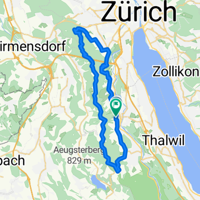
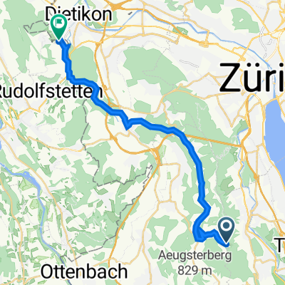
Zürich-Zugerland-Panoramaweg, Stallikon to Erlenstrasse 7, Bergdietikon
A cycling route starting in Adliswil / Sonnenberg, Canton of Zurich, Switzerland.
Overview
About this route
- 47 min
- Duration
- 19.4 km
- Distance
- 133 m
- Ascent
- 456 m
- Descent
- 24.9 km/h
- Avg. speed
- 789 m
- Avg. speed
Route quality
Waytypes & surfaces along the route
Waytypes
Quiet road
9.5 km
(49 %)
Road
3.7 km
(19 %)
Surfaces
Paved
16.7 km
(86 %)
Unpaved
0.7 km
(4 %)
Asphalt
14.5 km
(74 %)
Paved (undefined)
2.1 km
(11 %)
Continue with Bikemap
Use, edit, or download this cycling route
You would like to ride Zürich-Zugerland-Panoramaweg, Stallikon to Erlenstrasse 7, Bergdietikon or customize it for your own trip? Here is what you can do with this Bikemap route:
Free features
- Save this route as favorite or in collections
- Copy & plan your own version of this route
- Sync your route with Garmin or Wahoo
Premium features
Free trial for 3 days, or one-time payment. More about Bikemap Premium.
- Navigate this route on iOS & Android
- Export a GPX / KML file of this route
- Create your custom printout (try it for free)
- Download this route for offline navigation
Discover more Premium features.
Get Bikemap PremiumFrom our community
Other popular routes starting in Adliswil / Sonnenberg
 Von Adliswil, Rüschlikon, Horgenser Bergweiher, Hirzel, Baar Zug Zuger See, und über Sihlbrugg zurück nach ADLISWIL
- Distance
- 47.7 km
- Ascent
- 416 m
- Descent
- 436 m
- Location
- Adliswil / Sonnenberg, Canton of Zurich, Switzerland
 13.06.21
- Distance
- 28.1 km
- Ascent
- 939 m
- Descent
- 926 m
- Location
- Adliswil / Sonnenberg, Canton of Zurich, Switzerland
 Da Felseneggweg, Stallikon a Langwiesstrasse 18–24, Uitikon Waldegg
- Distance
- 11.3 km
- Ascent
- 131 m
- Descent
- 294 m
- Location
- Adliswil / Sonnenberg, Canton of Zurich, Switzerland
 Zürich-Zugerland-Panoramaweg, Stallikon to Erlenstrasse 7, Bergdietikon
- Distance
- 19.4 km
- Ascent
- 133 m
- Descent
- 456 m
- Location
- Adliswil / Sonnenberg, Canton of Zurich, Switzerland
 VCA Adliswil - Albis
- Distance
- 4.9 km
- Ascent
- 333 m
- Descent
- 45 m
- Location
- Adliswil / Sonnenberg, Canton of Zurich, Switzerland
 Aiyara
- Distance
- 7.3 km
- Ascent
- 64 m
- Descent
- 375 m
- Location
- Adliswil / Sonnenberg, Canton of Zurich, Switzerland
 Waldistrasse 10, Adliswil to Waldistrasse 10, Adliswil
- Distance
- 16.8 km
- Ascent
- 198 m
- Descent
- 197 m
- Location
- Adliswil / Sonnenberg, Canton of Zurich, Switzerland
 Adliswil-Susten
- Distance
- 242.3 km
- Ascent
- 3,013 m
- Descent
- 3,013 m
- Location
- Adliswil / Sonnenberg, Canton of Zurich, Switzerland
Open it in the app