

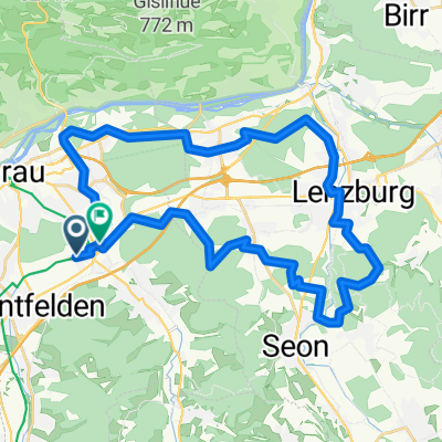
Grenzweg 2, Buchs AG nach Benkenstrasse 12, Küttigen
A cycling route starting in Suhr, Canton of Aargau, Switzerland.
Overview
About this route
- 18 min
- Duration
- 7.2 km
- Distance
- 97 m
- Ascent
- 58 m
- Descent
- 23.5 km/h
- Avg. speed
- 435 m
- Avg. speed

Route quality
Waytypes & surfaces along the route
Waytypes
Track
2.2 km
(31 %)
Busy road
1.9 km
(26 %)
Surfaces
Paved
5.2 km
(72 %)
Unpaved
1.1 km
(15 %)
Asphalt
4.3 km
(60 %)
Gravel
1 km
(14 %)
Continue with Bikemap
Use, edit, or download this cycling route
You would like to ride Grenzweg 2, Buchs AG nach Benkenstrasse 12, Küttigen or customize it for your own trip? Here is what you can do with this Bikemap route:
Free features
- Save this route as favorite or in collections
- Copy & plan your own version of this route
- Sync your route with Garmin or Wahoo
Premium features
Free trial for 3 days, or one-time payment. More about Bikemap Premium.
- Navigate this route on iOS & Android
- Export a GPX / KML file of this route
- Create your custom printout (try it for free)
- Download this route for offline navigation
Discover more Premium features.
Get Bikemap PremiumFrom our community
Other popular routes starting in Suhr
 A-Aarau-Wynental-Erlosen-Baldeggersee
- Distance
- 74.4 km
- Ascent
- 766 m
- Descent
- 765 m
- Location
- Suhr, Canton of Aargau, Switzerland
 Sempachersee
- Distance
- 76 km
- Ascent
- 440 m
- Descent
- 438 m
- Location
- Suhr, Canton of Aargau, Switzerland
 Gränichen,Brugg, Döttingen, Schlatt, Veltheim, Auenstein, Suhr Gänichen
- Distance
- 72.5 km
- Ascent
- 429 m
- Descent
- 429 m
- Location
- Suhr, Canton of Aargau, Switzerland
 Jowa
Jowa- Distance
- 9 km
- Ascent
- 87 m
- Descent
- 25 m
- Location
- Suhr, Canton of Aargau, Switzerland
 A-Aarau-Esterli-Lenzburg
- Distance
- 35 km
- Ascent
- 427 m
- Descent
- 430 m
- Location
- Suhr, Canton of Aargau, Switzerland
 Rheinland-Route 2012
- Distance
- 148.7 km
- Ascent
- 597 m
- Descent
- 596 m
- Location
- Suhr, Canton of Aargau, Switzerland
 Suhr - Homberg - Suhr
- Distance
- 44.5 km
- Ascent
- 614 m
- Descent
- 615 m
- Location
- Suhr, Canton of Aargau, Switzerland
 Helgenfeldweg 1, Suhr nach Muhenstrasse 6, Oberentfelden
- Distance
- 23.1 km
- Ascent
- 296 m
- Descent
- 278 m
- Location
- Suhr, Canton of Aargau, Switzerland
Open it in the app