
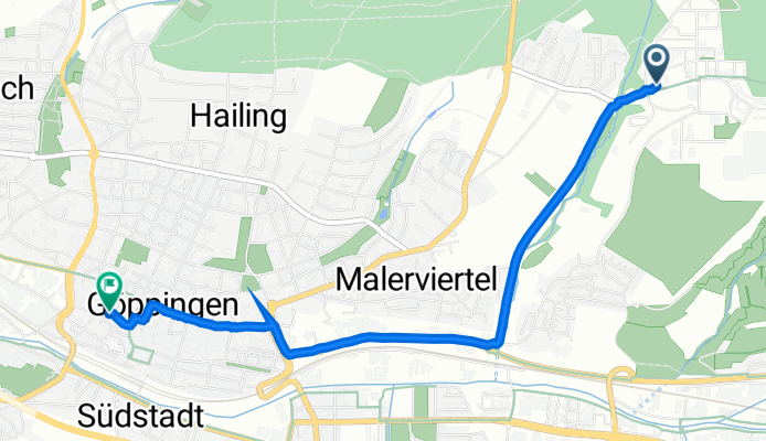
Manfred-Wörner-Straße 101, Göppingen nach Wühlestraße 36, Göppingen
A cycling route starting in Eislingen, Baden-Württemberg, Germany.
Overview
About this route
- 14 min
- Duration
- 3.7 km
- Distance
- 45 m
- Ascent
- 84 m
- Descent
- 15.6 km/h
- Avg. speed
- 360 m
- Avg. speed

Route quality
Waytypes & surfaces along the route
Waytypes
Pedestrian area
1.4 km
(38 %)
Quiet road
1.2 km
(34 %)
Surfaces
Paved
3.2 km
(85 %)
Asphalt
3.1 km
(82 %)
Paving stones
0.1 km
(3 %)
Undefined
0.6 km
(15 %)
Continue with Bikemap
Use, edit, or download this cycling route
You would like to ride Manfred-Wörner-Straße 101, Göppingen nach Wühlestraße 36, Göppingen or customize it for your own trip? Here is what you can do with this Bikemap route:
Free features
- Save this route as favorite or in collections
- Copy & plan your own version of this route
- Sync your route with Garmin or Wahoo
Premium features
Free trial for 3 days, or one-time payment. More about Bikemap Premium.
- Navigate this route on iOS & Android
- Export a GPX / KML file of this route
- Create your custom printout (try it for free)
- Download this route for offline navigation
Discover more Premium features.
Get Bikemap PremiumFrom our community
Other popular routes starting in Eislingen
 Schlater Wald über Grünenberg
- Distance
- 27.9 km
- Ascent
- 322 m
- Descent
- 322 m
- Location
- Eislingen, Baden-Württemberg, Germany
 Burren, Hexensattel und Hohenstaufen
- Distance
- 46.7 km
- Ascent
- 629 m
- Descent
- 606 m
- Location
- Eislingen, Baden-Württemberg, Germany
 Nassachtal-Herrenmühle
- Distance
- 36.9 km
- Ascent
- 241 m
- Descent
- 240 m
- Location
- Eislingen, Baden-Württemberg, Germany
 Hohenstaufen (über Göppingen)
- Distance
- 21.8 km
- Ascent
- 314 m
- Descent
- 317 m
- Location
- Eislingen, Baden-Württemberg, Germany
 "Trasse" und Rechberg
- Distance
- 40.5 km
- Ascent
- 442 m
- Descent
- 442 m
- Location
- Eislingen, Baden-Württemberg, Germany
 Esslingen
- Distance
- 35.6 km
- Ascent
- 17 m
- Descent
- 106 m
- Location
- Eislingen, Baden-Württemberg, Germany
 Hohenstaufen und Rechberg (über Göppingen)
- Distance
- 33.3 km
- Ascent
- 456 m
- Descent
- 453 m
- Location
- Eislingen, Baden-Württemberg, Germany
 Rechberg (Kapelle)
- Distance
- 22.8 km
- Ascent
- 446 m
- Descent
- 449 m
- Location
- Eislingen, Baden-Württemberg, Germany
Open it in the app