
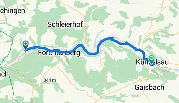
Graf-Wolfgang-Julius-Platz 2, Forchtenberg nach Hauptstraße 22, Künzelsau
A cycling route starting in Forchtenberg, Baden-Württemberg, Germany.
Overview
About this route
- 58 min
- Duration
- 17.1 km
- Distance
- 65 m
- Ascent
- 32 m
- Descent
- 17.5 km/h
- Avg. speed
- 227 m
- Avg. speed
Route quality
Waytypes & surfaces along the route
Waytypes
Quiet road
5.7 km
(33 %)
Track
5.5 km
(32 %)
Surfaces
Paved
16.7 km
(98 %)
Asphalt
16.4 km
(96 %)
Paving stones
0.3 km
(2 %)
Continue with Bikemap
Use, edit, or download this cycling route
You would like to ride Graf-Wolfgang-Julius-Platz 2, Forchtenberg nach Hauptstraße 22, Künzelsau or customize it for your own trip? Here is what you can do with this Bikemap route:
Free features
- Save this route as favorite or in collections
- Copy & plan your own version of this route
- Sync your route with Garmin or Wahoo
Premium features
Free trial for 3 days, or one-time payment. More about Bikemap Premium.
- Navigate this route on iOS & Android
- Export a GPX / KML file of this route
- Create your custom printout (try it for free)
- Download this route for offline navigation
Discover more Premium features.
Get Bikemap PremiumFrom our community
Other popular routes starting in Forchtenberg
 vom Kochertal durch Hardthäuser Wald nach Widdern und über Jagsthausen zurück
- Distance
- 30.6 km
- Ascent
- 426 m
- Descent
- 402 m
- Location
- Forchtenberg, Baden-Württemberg, Germany
 Von Ernsbach über Westernhausen Richtung Bieringen und vom Kloster Schöntal zurück
- Distance
- 37.4 km
- Ascent
- 621 m
- Descent
- 617 m
- Location
- Forchtenberg, Baden-Württemberg, Germany
 Trainingsrunde Kochertalexpress
- Distance
- 39.9 km
- Ascent
- 522 m
- Descent
- 522 m
- Location
- Forchtenberg, Baden-Württemberg, Germany
 Recovered Route
- Distance
- 18 km
- Ascent
- 25 m
- Descent
- 27 m
- Location
- Forchtenberg, Baden-Württemberg, Germany
 Ernsbach, Klosterwald, Hohe Straße, Bobachshof, Crispenhofen, Weißbach, Büschelfof, Forchtenberg
- Distance
- 38.4 km
- Ascent
- 595 m
- Descent
- 593 m
- Location
- Forchtenberg, Baden-Württemberg, Germany
 Kocher-Jagst3, Forcht-berg-Bad Friedr.hall
- Distance
- 37.7 km
- Ascent
- 84 m
- Descent
- 120 m
- Location
- Forchtenberg, Baden-Württemberg, Germany
 Forcht-Winterb
- Distance
- 77.3 km
- Ascent
- 866 m
- Descent
- 827 m
- Location
- Forchtenberg, Baden-Württemberg, Germany
 Samstag Durchdrehrunde mir einigen HM
- Distance
- 77.4 km
- Ascent
- 1,715 m
- Descent
- 1,693 m
- Location
- Forchtenberg, Baden-Württemberg, Germany
Open it in the app