
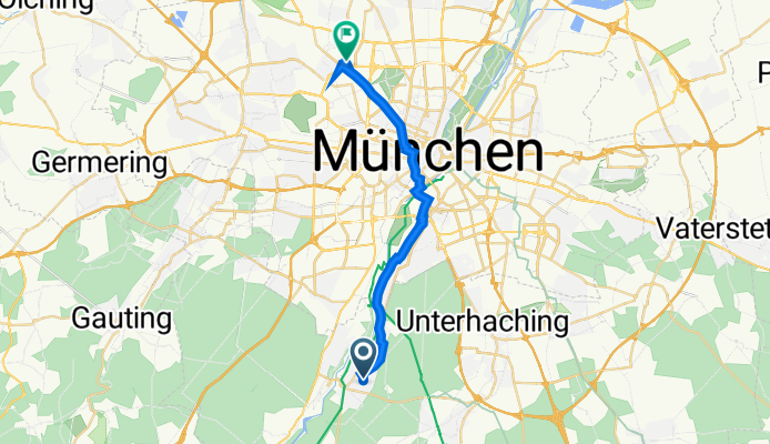
Schlehdornstraße 15, Grünwald nach Treitschkestraße 13, München
A cycling route starting in Grünwald, Bavaria, Germany.
Overview
About this route
- 1 h 2 min
- Duration
- 19.6 km
- Distance
- 16 m
- Ascent
- 147 m
- Descent
- 19 km/h
- Avg. speed
- 639 m
- Avg. speed

Route quality
Waytypes & surfaces along the route
Waytypes
Path
11.2 km
(57 %)
Quiet road
5 km
(25 %)
Surfaces
Paved
18.7 km
(95 %)
Asphalt
17.2 km
(88 %)
Paved (undefined)
1.1 km
(6 %)
Continue with Bikemap
Use, edit, or download this cycling route
You would like to ride Schlehdornstraße 15, Grünwald nach Treitschkestraße 13, München or customize it for your own trip? Here is what you can do with this Bikemap route:
Free features
- Save this route as favorite or in collections
- Copy & plan your own version of this route
- Sync your route with Garmin or Wahoo
Premium features
Free trial for 3 days, or one-time payment. More about Bikemap Premium.
- Navigate this route on iOS & Android
- Export a GPX / KML file of this route
- Create your custom printout (try it for free)
- Download this route for offline navigation
Discover more Premium features.
Get Bikemap PremiumFrom our community
Other popular routes starting in Grünwald
 Grünwald-Schäftlarn-Runde
- Distance
- 24.2 km
- Ascent
- 280 m
- Descent
- 300 m
- Location
- Grünwald, Bavaria, Germany
 Kleine Grünwald - Schäftlarn Runde
- Distance
- 26.1 km
- Ascent
- 373 m
- Descent
- 352 m
- Location
- Grünwald, Bavaria, Germany
 München-Gardasee
- Distance
- 442.8 km
- Ascent
- 1,667 m
- Descent
- 2,168 m
- Location
- Grünwald, Bavaria, Germany
 Höllriegelskreuth, Schäftlarn, Berg, Ambach, Wolfratshausen
- Distance
- 46 km
- Ascent
- 382 m
- Descent
- 403 m
- Location
- Grünwald, Bavaria, Germany
 Route nach Albert-Roßhaupter-Straße 72, München
- Distance
- 15.2 km
- Ascent
- 1,059 m
- Descent
- 1,115 m
- Location
- Grünwald, Bavaria, Germany
 Alpencross 2010
- Distance
- 800.6 km
- Ascent
- 11,261 m
- Descent
- 11,780 m
- Location
- Grünwald, Bavaria, Germany
 Rundtour (Hochufer an der Isar)
- Distance
- 43.8 km
- Ascent
- 420 m
- Descent
- 420 m
- Location
- Grünwald, Bavaria, Germany
 Grünwald - Wolfratshausen
- Distance
- 17.8 km
- Ascent
- 94 m
- Descent
- 122 m
- Location
- Grünwald, Bavaria, Germany
Open it in the app