

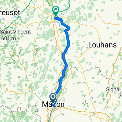
ETAPPE 6 - Macon nach Lyon
A cycling route starting in Mâcon, Bourgogne-Franche-Comté, France.
Overview
About this route
- -:--
- Duration
- 87.1 km
- Distance
- 220 m
- Ascent
- 226 m
- Descent
- ---
- Avg. speed
- 182 m
- Avg. speed

Route quality
Waytypes & surfaces along the route
Waytypes
Path
32 km
(37 %)
Track
21.1 km
(24 %)
Surfaces
Paved
35.5 km
(41 %)
Unpaved
41.9 km
(48 %)
Gravel
35.8 km
(41 %)
Asphalt
34 km
(39 %)
Continue with Bikemap
Use, edit, or download this cycling route
You would like to ride ETAPPE 6 - Macon nach Lyon or customize it for your own trip? Here is what you can do with this Bikemap route:
Free features
- Save this route as favorite or in collections
- Copy & plan your own version of this route
- Sync your route with Garmin or Wahoo
Premium features
Free trial for 3 days, or one-time payment. More about Bikemap Premium.
- Navigate this route on iOS & Android
- Export a GPX / KML file of this route
- Create your custom printout (try it for free)
- Download this route for offline navigation
Discover more Premium features.
Get Bikemap PremiumFrom our community
Other popular routes starting in Mâcon
 Girolibero: Borgogna
- Distance
- 122.2 km
- Ascent
- 1,370 m
- Descent
- 1,325 m
- Location
- Mâcon, Bourgogne-Franche-Comté, France
 BURGUNDSKO - KRAJEM VÍNA (CHATKY)
- Distance
- 340.2 km
- Ascent
- 1,136 m
- Descent
- 1,096 m
- Location
- Mâcon, Bourgogne-Franche-Comté, France
 De Route de Bioux 5, Mâcon à Route de Bioux 5, Mâcon
- Distance
- 39.1 km
- Ascent
- 585 m
- Descent
- 585 m
- Location
- Mâcon, Bourgogne-Franche-Comté, France
 Voie de Bourgogne par Cluny
- Distance
- 86.6 km
- Ascent
- 336 m
- Descent
- 344 m
- Location
- Mâcon, Bourgogne-Franche-Comté, France
 Tour de Bourgogne du Sud #3
- Distance
- 67.1 km
- Ascent
- 167 m
- Descent
- 177 m
- Location
- Mâcon, Bourgogne-Franche-Comté, France
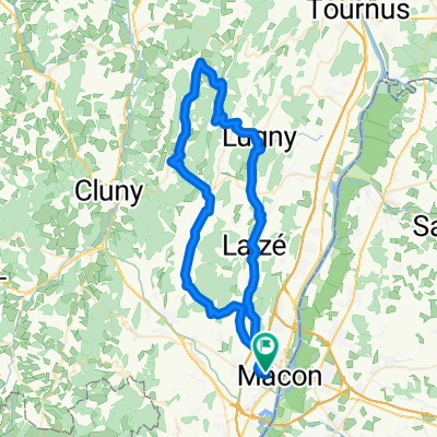 68 km - 900 m Péronne Lugny Pistole Blanot Azé Verzé Hurigny
- Distance
- 68.6 km
- Ascent
- 790 m
- Descent
- 790 m
- Location
- Mâcon, Bourgogne-Franche-Comté, France
 Untitled route
- Distance
- 396.4 km
- Ascent
- 1,362 m
- Descent
- 1,457 m
- Location
- Mâcon, Bourgogne-Franche-Comté, France
 Mâcon Tournus Pont-de-Vaux Milly-Lamartine
- Distance
- 115.8 km
- Ascent
- 258 m
- Descent
- 259 m
- Location
- Mâcon, Bourgogne-Franche-Comté, France
Open it in the app