

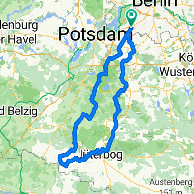
Zehlendorf - Potsdam - Borkwalde - Lehnin - Schenkenberg bis Fähre Ketzin
A cycling route starting in Zehlendorf, Land Berlin, Germany.
Overview
About this route
Grosse Südwestrunde: Zehlendorf - Potsdam - Borkwalde - Lehnin - Schenkenberg bis Fähre Ketzin
- -:--
- Duration
- 93 km
- Distance
- 450 m
- Ascent
- 468 m
- Descent
- ---
- Avg. speed
- 87 m
- Avg. speed
Route quality
Waytypes & surfaces along the route
Waytypes
Path
25.1 km
(27 %)
Quiet road
19.1 km
(21 %)
Surfaces
Paved
89.2 km
(96 %)
Unpaved
0.7 km
(<1 %)
Asphalt
82.3 km
(88 %)
Paving stones
5.5 km
(6 %)
Continue with Bikemap
Use, edit, or download this cycling route
You would like to ride Zehlendorf - Potsdam - Borkwalde - Lehnin - Schenkenberg bis Fähre Ketzin or customize it for your own trip? Here is what you can do with this Bikemap route:
Free features
- Save this route as favorite or in collections
- Copy & plan your own version of this route
- Sync your route with Garmin or Wahoo
Premium features
Free trial for 3 days, or one-time payment. More about Bikemap Premium.
- Navigate this route on iOS & Android
- Export a GPX / KML file of this route
- Create your custom printout (try it for free)
- Download this route for offline navigation
Discover more Premium features.
Get Bikemap PremiumFrom our community
Other popular routes starting in Zehlendorf
 Berlin - Dobbrikow - Fläming - Jüterbog - Berlin
- Distance
- 156.8 km
- Ascent
- 378 m
- Descent
- 381 m
- Location
- Zehlendorf, Land Berlin, Germany
 grunerunde
- Distance
- 31.4 km
- Ascent
- 181 m
- Descent
- 178 m
- Location
- Zehlendorf, Land Berlin, Germany
 Zehlendorf -> Trebbin
- Distance
- 72.6 km
- Ascent
- 96 m
- Descent
- 95 m
- Location
- Zehlendorf, Land Berlin, Germany
 Berliner Mauerweg
- Distance
- 172.8 km
- Ascent
- 175 m
- Descent
- 181 m
- Location
- Zehlendorf, Land Berlin, Germany
 Zehlendorf -> Fresdorf -> Caputh -> Teufelsberg
- Distance
- 85.4 km
- Ascent
- 298 m
- Descent
- 287 m
- Location
- Zehlendorf, Land Berlin, Germany
 Radtour Südlich von Berlin
- Distance
- 68.2 km
- Ascent
- 117 m
- Descent
- 117 m
- Location
- Zehlendorf, Land Berlin, Germany
 S Zehlendorf -> Tremsdorf -> Caputh -> Auerbachtunnel
- Distance
- 65.4 km
- Ascent
- 258 m
- Descent
- 245 m
- Location
- Zehlendorf, Land Berlin, Germany
 RTF 24. Eichh. 2. Runde
- Distance
- 40.5 km
- Ascent
- 112 m
- Descent
- 116 m
- Location
- Zehlendorf, Land Berlin, Germany
Open it in the app