
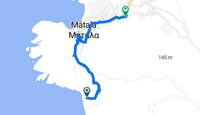
Red Beach Trail, Matala nach Eparchiaki Odos Gortinas - Matalon, Matala
A cycling route starting in Tympaki, Crete, Greece.
Overview
About this route
- 52 min
- Duration
- 1.6 km
- Distance
- 101 m
- Ascent
- 88 m
- Descent
- 1.8 km/h
- Avg. speed
- 89 m
- Avg. speed

Continue with Bikemap
Use, edit, or download this cycling route
You would like to ride Red Beach Trail, Matala nach Eparchiaki Odos Gortinas - Matalon, Matala or customize it for your own trip? Here is what you can do with this Bikemap route:
Free features
- Save this route as favorite or in collections
- Copy & plan your own version of this route
- Sync your route with Garmin or Wahoo
Premium features
Free trial for 3 days, or one-time payment. More about Bikemap Premium.
- Navigate this route on iOS & Android
- Export a GPX / KML file of this route
- Create your custom printout (try it for free)
- Download this route for offline navigation
Discover more Premium features.
Get Bikemap PremiumFrom our community
Other popular routes starting in Tympaki
 RTF Sued Kreta ?
- Distance
- 123.5 km
- Ascent
- 1,282 m
- Descent
- 1,279 m
- Location
- Tympaki, Crete, Greece
 Mires Platanos Kefala RW um das Hügelplateau 5,6 Km
- Distance
- 5.6 km
- Ascent
- 128 m
- Descent
- 125 m
- Location
- Tympaki, Crete, Greece
 Kreta 2022 Matala-Mirtos (2)
- Distance
- 102.8 km
- Ascent
- 1,564 m
- Descent
- 1,555 m
- Location
- Tympaki, Crete, Greece
 Rundtur Landros, Mirtos, Kofinas
- Distance
- 213.2 km
- Ascent
- 2,415 m
- Descent
- 2,408 m
- Location
- Tympaki, Crete, Greece
 Ziua 8 V2_Matala_Heraklion_66/760
- Distance
- 66.4 km
- Ascent
- 732 m
- Descent
- 733 m
- Location
- Tympaki, Crete, Greece
 Landros - Kato Asites
- Distance
- 44.6 km
- Ascent
- 836 m
- Descent
- 500 m
- Location
- Tympaki, Crete, Greece
 Sivas Kefali
- Distance
- 31.6 km
- Ascent
- 752 m
- Descent
- 752 m
- Location
- Tympaki, Crete, Greece
 Kreta Tag 12
- Distance
- 42.2 km
- Ascent
- 741 m
- Descent
- 454 m
- Location
- Tympaki, Crete, Greece
Open it in the app