

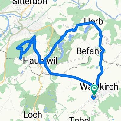
Obere Rebrainstrasse 25, Hauptwil-Gottshaus nach Städelistrasse 8, Gossau
A cycling route starting in Waldkirch, Canton of St. Gallen, Switzerland.
Overview
About this route
- 48 min
- Duration
- 9.8 km
- Distance
- 134 m
- Ascent
- 106 m
- Descent
- 12.3 km/h
- Avg. speed
- 653 m
- Avg. speed

Route quality
Waytypes & surfaces along the route
Waytypes
Quiet road
4.4 km
(45 %)
Track
3.5 km
(35 %)
Surfaces
Paved
0.9 km
(9 %)
Unpaved
3.4 km
(35 %)
Gravel
3.2 km
(33 %)
Asphalt
0.7 km
(7 %)
Continue with Bikemap
Use, edit, or download this cycling route
You would like to ride Obere Rebrainstrasse 25, Hauptwil-Gottshaus nach Städelistrasse 8, Gossau or customize it for your own trip? Here is what you can do with this Bikemap route:
Free features
- Save this route as favorite or in collections
- Copy & plan your own version of this route
- Sync your route with Garmin or Wahoo
Premium features
Free trial for 3 days, or one-time payment. More about Bikemap Premium.
- Navigate this route on iOS & Android
- Export a GPX / KML file of this route
- Create your custom printout (try it for free)
- Download this route for offline navigation
Discover more Premium features.
Get Bikemap PremiumFrom our community
Other popular routes starting in Waldkirch
 Tannenberg (Waldkirch) - Siebnen
- Distance
- 78.9 km
- Ascent
- 447 m
- Descent
- 877 m
- Location
- Waldkirch, Canton of St. Gallen, Switzerland
 Hochgeschwindigkeitsroute in Hauptwil
- Distance
- 14.8 km
- Ascent
- 247 m
- Descent
- 238 m
- Location
- Waldkirch, Canton of St. Gallen, Switzerland
 Bischofszell, Hagenwil, Buchackern, Hummelberh, Bischofszell
- Distance
- 24.5 km
- Ascent
- 300 m
- Descent
- 294 m
- Location
- Waldkirch, Canton of St. Gallen, Switzerland
 Rome, Etappe 6, Bischofszell - Chur
- Distance
- 136.2 km
- Ascent
- 246 m
- Descent
- 164 m
- Location
- Waldkirch, Canton of St. Gallen, Switzerland
 Waldkirch - Thur - Niederhelfenschwil - Waldschenke - Waldkirch
- Distance
- 30.2 km
- Ascent
- 367 m
- Descent
- 379 m
- Location
- Waldkirch, Canton of St. Gallen, Switzerland
 Bischofszell Route
- Distance
- 15.5 km
- Ascent
- 210 m
- Descent
- 212 m
- Location
- Waldkirch, Canton of St. Gallen, Switzerland
 HauptwilRomanshornAltnau
- Distance
- 56 km
- Ascent
- 493 m
- Descent
- 481 m
- Location
- Waldkirch, Canton of St. Gallen, Switzerland
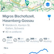 Migros Bischofszell, Hasenberg-Gossau
- Distance
- 15.2 km
- Ascent
- 267 m
- Descent
- 126 m
- Location
- Waldkirch, Canton of St. Gallen, Switzerland
Open it in the app