
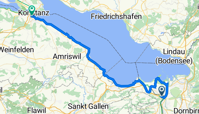
Grasbäustrasse 8, St. Margrethen SG nach Bahnhofstrasse 14, Kreuzlingen
A cycling route starting in Sankt Margrethen, Canton of St. Gallen, Switzerland.
Overview
About this route
- 3 h 52 min
- Duration
- 62.9 km
- Distance
- 201 m
- Ascent
- 196 m
- Descent
- 16.3 km/h
- Avg. speed
- 425 m
- Avg. speed
Route quality
Waytypes & surfaces along the route
Waytypes
Quiet road
31.2 km
(50 %)
Cycleway
16.7 km
(27 %)
Surfaces
Paved
57.2 km
(91 %)
Unpaved
5.6 km
(9 %)
Asphalt
57.1 km
(91 %)
Gravel
3.6 km
(6 %)
Continue with Bikemap
Use, edit, or download this cycling route
You would like to ride Grasbäustrasse 8, St. Margrethen SG nach Bahnhofstrasse 14, Kreuzlingen or customize it for your own trip? Here is what you can do with this Bikemap route:
Free features
- Save this route as favorite or in collections
- Copy & plan your own version of this route
- Sync your route with Garmin or Wahoo
Premium features
Free trial for 3 days, or one-time payment. More about Bikemap Premium.
- Navigate this route on iOS & Android
- Export a GPX / KML file of this route
- Create your custom printout (try it for free)
- Download this route for offline navigation
Discover more Premium features.
Get Bikemap PremiumFrom our community
Other popular routes starting in Sankt Margrethen
 Alpenpanorama- Route Nr. 4
- Distance
- 478.9 km
- Ascent
- 12,216 m
- Descent
- 12,212 m
- Location
- Sankt Margrethen, Canton of St. Gallen, Switzerland
 St.Anton
- Distance
- 38.3 km
- Ascent
- 852 m
- Descent
- 849 m
- Location
- Sankt Margrethen, Canton of St. Gallen, Switzerland
 Höchst - Walzenhausen - Heiden - Retour
- Distance
- 26 km
- Ascent
- 759 m
- Descent
- 759 m
- Location
- Sankt Margrethen, Canton of St. Gallen, Switzerland
 Höchst-Konstanz (3)
- Distance
- 53.1 km
- Ascent
- 57 m
- Descent
- 56 m
- Location
- Sankt Margrethen, Canton of St. Gallen, Switzerland
 4-Tages-Passfahrt Vorarlberg-Italien-Graubünden
- Distance
- 330.4 km
- Ascent
- 4,568 m
- Descent
- 4,447 m
- Location
- Sankt Margrethen, Canton of St. Gallen, Switzerland
 Bodensee-Comer See
- Distance
- 315.6 km
- Ascent
- 2,560 m
- Descent
- 2,523 m
- Location
- Sankt Margrethen, Canton of St. Gallen, Switzerland
 BRUTAL 2013 Rainer Waigel Variante A-CH
- Distance
- 1,016.5 km
- Ascent
- 8,675 m
- Descent
- 8,658 m
- Location
- Sankt Margrethen, Canton of St. Gallen, Switzerland
 SchweizMobil 4: Alpenpanorama-Route
- Distance
- 480 km
- Ascent
- 8,734 m
- Descent
- 8,732 m
- Location
- Sankt Margrethen, Canton of St. Gallen, Switzerland
Open it in the app