Premium Badge Download on the App Store Get it on Google Play Turn-by-turn Navigation Offline Maps Bike Type Optimized Routing Premium Maps Custom Bike Computer Export Routes Route Previews Fall Detection Premium Support

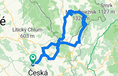
Cycling Route in Ústí nad Orlicí, Pardubický kraj, Czechia

Tour de Králický Sněžník 2023

0
Open this route in the Bikemap app

Open this route in the Bikemap app

Open this route in Bikemap Web

Open this route in Bikemap Web

151 km
Distance
2735 m
Ascent
2736 m
Descent
-:-- h
Duration
-- km/h
Avg. Speed
1419 m
Max. Elevation

About This Route

Ústí nad Orlicí - Lanšperk - Hnátnice - Valdštejn - Letohrad - Lukavice - Zakopanka - Líšnice - Pastviny - Vlčkovice - Mladkov - Petrovičky - CZ/PL - Kamienczyk - Smreczyna - Miedzylesie - Roztoki - Domaszków - Wilkanów - Marianówka - Idzików - Sienna - Janova Góra - Jaskinia Niedzwiedzia - Przelecz Snieznicka - Schronisko PTTK - Králický Sněžník (Cima Coppi) - Pramen Moravy - Franciska - Sněžná chata - Pod Vilemínkou - Horní Morava - Dolní Morava - Červený Potok - Králíky - Dolní Lipka - Lichkov - Mladkov - Celné - Těchonín - Jablonné nad Orlicí - Verměřovice - Letohrad - Lanšperk - Ústí nad Orlicí

Sella di Zakopanka (478 m)

Colle di Adamo (705 m)

Przelecz Puchaczówka (896 m)

Przelecz Snieznicka (1123 m)

Rifugio Svizzera (1218 m)

Monte della Neve (1423 m)


This cycling route is ideal for: Road bike

You will cycle on the following surfaces: Paved

Customize this cycling route with the Bikemap route planner.

Make it yours!

Did you know? You can use this route as a template in our cycling route planner if you don't wish to start from scratch. Customize it based on your needs to plan your perfect cycling tour.

Open it in the app