

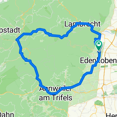
Brunnenstraße 24, Maikammer nach Brunnenstraße 21, Maikammer
A cycling route starting in Maikammer, Rhineland-Palatinate, Germany.
Overview
About this route
- 1 h 18 min
- Duration
- 24 km
- Distance
- 163 m
- Ascent
- 161 m
- Descent
- 18.5 km/h
- Avg. speed
- 180 m
- Avg. speed

Route quality
Waytypes & surfaces along the route
Waytypes
Track
8.4 km
(35 %)
Busy road
6.9 km
(29 %)
Surfaces
Paved
21.2 km
(88 %)
Unpaved
0 km
(<1 %)
Asphalt
14.8 km
(62 %)
Paved (undefined)
3.6 km
(15 %)
Continue with Bikemap
Use, edit, or download this cycling route
You would like to ride Brunnenstraße 24, Maikammer nach Brunnenstraße 21, Maikammer or customize it for your own trip? Here is what you can do with this Bikemap route:
Free features
- Save this route as favorite or in collections
- Copy & plan your own version of this route
- Sync your route with Garmin or Wahoo
Premium features
Free trial for 3 days, or one-time payment. More about Bikemap Premium.
- Navigate this route on iOS & Android
- Export a GPX / KML file of this route
- Create your custom printout (try it for free)
- Download this route for offline navigation
Discover more Premium features.
Get Bikemap PremiumFrom our community
Other popular routes starting in Maikammer
 kraft am berg
- Distance
- 79 km
- Ascent
- 1,595 m
- Descent
- 1,626 m
- Location
- Maikammer, Rhineland-Palatinate, Germany
 5 Berge
- Distance
- 68.8 km
- Ascent
- 1,713 m
- Descent
- 1,581 m
- Location
- Maikammer, Rhineland-Palatinate, Germany
 Neustadt-kleine Runde
- Distance
- 21.9 km
- Ascent
- 98 m
- Descent
- 98 m
- Location
- Maikammer, Rhineland-Palatinate, Germany
 Godrammstein
- Distance
- 40.6 km
- Ascent
- 223 m
- Descent
- 223 m
- Location
- Maikammer, Rhineland-Palatinate, Germany
 Tagestour Pfalz
- Distance
- 58.8 km
- Ascent
- 1,658 m
- Descent
- 1,669 m
- Location
- Maikammer, Rhineland-Palatinate, Germany
 Radtour Pfalz 4
- Distance
- 41.9 km
- Ascent
- 294 m
- Descent
- 294 m
- Location
- Maikammer, Rhineland-Palatinate, Germany
 Pfälzerwald mit Hambach
- Distance
- 88.2 km
- Ascent
- 791 m
- Descent
- 779 m
- Location
- Maikammer, Rhineland-Palatinate, Germany
 Hohe Loog, Kalmit, Edenkobener Tal
- Distance
- 30 km
- Ascent
- 657 m
- Descent
- 586 m
- Location
- Maikammer, Rhineland-Palatinate, Germany
Open it in the app