
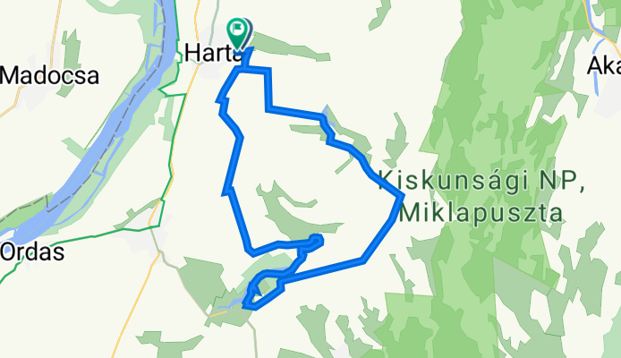
Templom utca 127., Harta to Jókai Mór utca 39., Harta
A cycling route starting in Harta, Bács-Kiskun county, Hungary.
Overview
About this route
- 1 h 48 min
- Duration
- 30.2 km
- Distance
- 270 m
- Ascent
- 271 m
- Descent
- 16.7 km/h
- Avg. speed
- 181 m
- Avg. speed
Continue with Bikemap
Use, edit, or download this cycling route
You would like to ride Templom utca 127., Harta to Jókai Mór utca 39., Harta or customize it for your own trip? Here is what you can do with this Bikemap route:
Free features
- Save this route as favorite or in collections
- Copy & plan your own version of this route
- Sync your route with Garmin or Wahoo
Premium features
Free trial for 3 days, or one-time payment. More about Bikemap Premium.
- Navigate this route on iOS & Android
- Export a GPX / KML file of this route
- Create your custom printout (try it for free)
- Download this route for offline navigation
Discover more Premium features.
Get Bikemap PremiumFrom our community
Other popular routes starting in Harta
 2016 09 09 Harta 33 km
- Distance
- 32 km
- Ascent
- 13 m
- Descent
- 15 m
- Location
- Harta, Bács-Kiskun county, Hungary
 1.10
1.10- Distance
- 72.5 km
- Ascent
- 92 m
- Descent
- 29 m
- Location
- Harta, Bács-Kiskun county, Hungary
 Eurovelo 6 - 7. nap
- Distance
- 64.7 km
- Ascent
- 35 m
- Descent
- 43 m
- Location
- Harta, Bács-Kiskun county, Hungary
 ghbrthe
- Distance
- 40.3 km
- Ascent
- 28 m
- Descent
- 30 m
- Location
- Harta, Bács-Kiskun county, Hungary
 Harta-Pécsvárad
- Distance
- 105.8 km
- Ascent
- 316 m
- Descent
- 205 m
- Location
- Harta, Bács-Kiskun county, Hungary
 Easy ride in Harta
- Distance
- 3.5 km
- Ascent
- 14 m
- Descent
- 15 m
- Location
- Harta, Bács-Kiskun county, Hungary
 Z8_Harta Mochacks EV6
- Distance
- 106.1 km
- Ascent
- 54 m
- Descent
- 60 m
- Location
- Harta, Bács-Kiskun county, Hungary
 Harta-Kalocsa- Szekszárd-Pécsvárad
- Distance
- 116.7 km
- Ascent
- 370 m
- Descent
- 234 m
- Location
- Harta, Bács-Kiskun county, Hungary
Open it in the app