
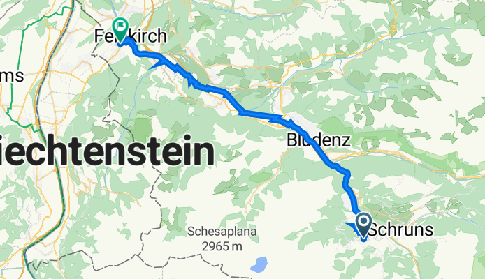
Latschaustraße 45A, Tschagguns nach Carinagasse 14, Feldkirch
A cycling route starting in Tschagguns, Vorarlberg, Austria.
Overview
About this route
- 1 h 50 min
- Duration
- 36.7 km
- Distance
- 1,087 m
- Ascent
- 1,623 m
- Descent
- 20 km/h
- Avg. speed
- 1,013 m
- Avg. speed
Route quality
Waytypes & surfaces along the route
Waytypes
Path
13.5 km
(37 %)
Quiet road
9 km
(25 %)
Surfaces
Paved
32.3 km
(88 %)
Unpaved
4 km
(11 %)
Asphalt
32.3 km
(88 %)
Gravel
3.1 km
(8 %)
Continue with Bikemap
Use, edit, or download this cycling route
You would like to ride Latschaustraße 45A, Tschagguns nach Carinagasse 14, Feldkirch or customize it for your own trip? Here is what you can do with this Bikemap route:
Free features
- Save this route as favorite or in collections
- Copy & plan your own version of this route
- Sync your route with Garmin or Wahoo
Premium features
Free trial for 3 days, or one-time payment. More about Bikemap Premium.
- Navigate this route on iOS & Android
- Export a GPX / KML file of this route
- Create your custom printout (try it for free)
- Download this route for offline navigation
Discover more Premium features.
Get Bikemap PremiumFrom our community
Other popular routes starting in Tschagguns
 Schruns nach Landeck
- Distance
- 83.6 km
- Ascent
- 3,276 m
- Descent
- 3,163 m
- Location
- Tschagguns, Vorarlberg, Austria
 Tannenweg, Bartholomäberg nach Alte Riederstraße, Vandans
- Distance
- 1.7 km
- Ascent
- 99 m
- Descent
- 77 m
- Location
- Tschagguns, Vorarlberg, Austria
 Schruns Matschwitz Golm 23 km 820 hm
- Distance
- 22 km
- Ascent
- 973 m
- Descent
- 973 m
- Location
- Tschagguns, Vorarlberg, Austria
 Vandans - Saas
- Distance
- 34.2 km
- Ascent
- 1,542 m
- Descent
- 1,557 m
- Location
- Tschagguns, Vorarlberg, Austria
 2019 - Bieler Höhe
- Distance
- 79.9 km
- Ascent
- 1,644 m
- Descent
- 1,640 m
- Location
- Tschagguns, Vorarlberg, Austria
 Tilisunahütte
- Distance
- 34.2 km
- Ascent
- 2,136 m
- Descent
- 2,116 m
- Location
- Tschagguns, Vorarlberg, Austria
 3-Täler-Fahrt
- Distance
- 139.1 km
- Ascent
- 2,280 m
- Descent
- 2,281 m
- Location
- Tschagguns, Vorarlberg, Austria
 Latschau - Lindauerhütte 14 km - 750hm
- Distance
- 7.1 km
- Ascent
- 765 m
- Descent
- 22 m
- Location
- Tschagguns, Vorarlberg, Austria
Open it in the app