
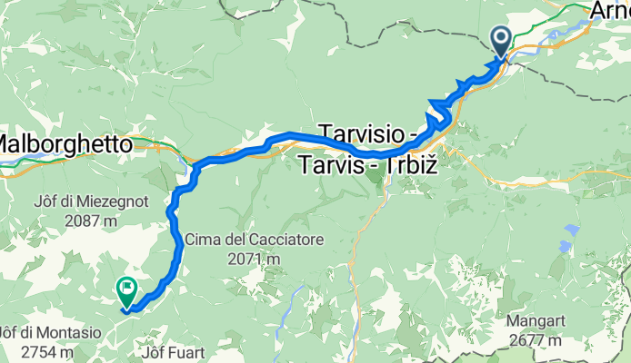
SS13 31, Tarvisio nach Strada senza nome, Malborghetto Valbruna
A cycling route starting in Hohenthurn, Carinthia, Austria.
Overview
About this route
- 1 h 12 min
- Duration
- 21.8 km
- Distance
- 739 m
- Ascent
- 418 m
- Descent
- 18.1 km/h
- Avg. speed
- 1,005 m
- Avg. speed

Route quality
Waytypes & surfaces along the route
Waytypes
Cycleway
12 km
(55 %)
Road
5.9 km
(27 %)
Surfaces
Paved
16.2 km
(74 %)
Unpaved
0 km
(<1 %)
Asphalt
15.8 km
(72 %)
Paved (undefined)
0.3 km
(1 %)
Continue with Bikemap
Use, edit, or download this cycling route
You would like to ride SS13 31, Tarvisio nach Strada senza nome, Malborghetto Valbruna or customize it for your own trip? Here is what you can do with this Bikemap route:
Free features
- Save this route as favorite or in collections
- Copy & plan your own version of this route
- Sync your route with Garmin or Wahoo
Premium features
Free trial for 3 days, or one-time payment. More about Bikemap Premium.
- Navigate this route on iOS & Android
- Export a GPX / KML file of this route
- Create your custom printout (try it for free)
- Download this route for offline navigation
Discover more Premium features.
Get Bikemap PremiumFrom our community
Other popular routes starting in Hohenthurn
 Von Arnoldstein bis Jesenice
- Distance
- 48.3 km
- Ascent
- 979 m
- Descent
- 1,065 m
- Location
- Hohenthurn, Carinthia, Austria
 Bartolosattel
- Distance
- 32.1 km
- Ascent
- 660 m
- Descent
- 657 m
- Location
- Hohenthurn, Carinthia, Austria
 Tarvis Bled
- Distance
- 59.8 km
- Ascent
- 831 m
- Descent
- 1,011 m
- Location
- Hohenthurn, Carinthia, Austria
 MTB-Trail: ThörlMaglernZoll-Pressendellach-Draschitz-Göriach-Achomitz-AchomitzerAlm-TRAIL-WW508-ArlecchinoTRAIL-Camporosso-Tarvisio-Coccau-ThörlMaglernZoll
- Distance
- 37.4 km
- Ascent
- 1,474 m
- Descent
- 1,470 m
- Location
- Hohenthurn, Carinthia, Austria
 Hohenthurn Radfahren
- Distance
- 97.3 km
- Ascent
- 1,262 m
- Descent
- 1,245 m
- Location
- Hohenthurn, Carinthia, Austria
 MTB-Berg: Draschitz - Feistritz/Gail - Feistritzbach - Bartolosattel - Tarvisio - Unterthörl - Draschitz
- Distance
- 30.3 km
- Ascent
- 900 m
- Descent
- 901 m
- Location
- Hohenthurn, Carinthia, Austria
 MTB-Berg/Trail IMPORT: Bartolosattel-Achomitzer Alm
- Distance
- 39.6 km
- Ascent
- 1,185 m
- Descent
- 1,167 m
- Location
- Hohenthurn, Carinthia, Austria
 🚴♀️E*Bike🇦🇹 17.05.20. 4. Tag Kanatalradweg
- Distance
- 53.1 km
- Ascent
- 304 m
- Descent
- 636 m
- Location
- Hohenthurn, Carinthia, Austria
Open it in the app