
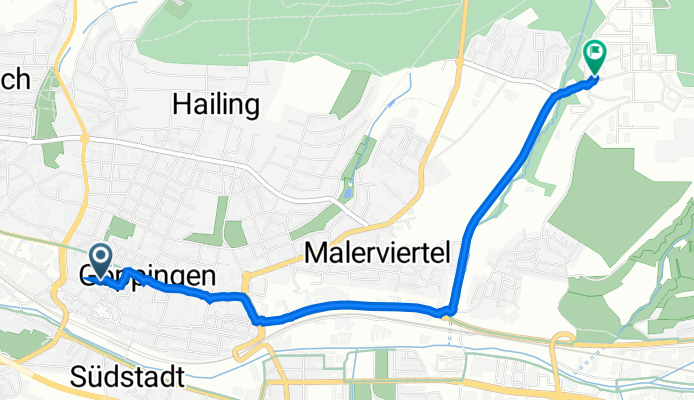
Wühlestraße 31, Göppingen nach Manfred-Wörner-Straße 101, Göppingen
A cycling route starting in Göppingen, Baden-Württemberg, Germany.
Overview
About this route
- 14 min
- Duration
- 3.7 km
- Distance
- 57 m
- Ascent
- 18 m
- Descent
- 16.5 km/h
- Avg. speed
- 358 m
- Avg. speed

Route quality
Waytypes & surfaces along the route
Waytypes
Quiet road
1.5 km
(41 %)
Pedestrian area
1.4 km
(38 %)
Surfaces
Paved
3.2 km
(87 %)
Asphalt
3.2 km
(87 %)
Undefined
0.5 km
(13 %)
Continue with Bikemap
Use, edit, or download this cycling route
You would like to ride Wühlestraße 31, Göppingen nach Manfred-Wörner-Straße 101, Göppingen or customize it for your own trip? Here is what you can do with this Bikemap route:
Free features
- Save this route as favorite or in collections
- Copy & plan your own version of this route
- Sync your route with Garmin or Wahoo
Premium features
Free trial for 3 days, or one-time payment. More about Bikemap Premium.
- Navigate this route on iOS & Android
- Export a GPX / KML file of this route
- Create your custom printout (try it for free)
- Download this route for offline navigation
Discover more Premium features.
Get Bikemap PremiumFrom our community
Other popular routes starting in Göppingen
 Training
- Distance
- 50.1 km
- Ascent
- 1,393 m
- Descent
- 1,504 m
- Location
- Göppingen, Baden-Württemberg, Germany
 Barbarossa-Lauf
- Distance
- 21.2 km
- Ascent
- 533 m
- Descent
- 483 m
- Location
- Göppingen, Baden-Württemberg, Germany
 Göppingen - Drei Kaiser Berge
- Distance
- 31.8 km
- Ascent
- 770 m
- Descent
- 766 m
- Location
- Göppingen, Baden-Württemberg, Germany
 Göppingen - Weilheim - Schopfloch - Donnstetten - Wiesensteig - Schlat - Göppingen
- Distance
- 73 km
- Ascent
- 788 m
- Descent
- 788 m
- Location
- Göppingen, Baden-Württemberg, Germany
 Göppingen - Gingen - Bad Ditzenbach - Fuchseck
- Distance
- 48.9 km
- Ascent
- 747 m
- Descent
- 747 m
- Location
- Göppingen, Baden-Württemberg, Germany
 Abendrunde MTB
- Distance
- 23.6 km
- Ascent
- 191 m
- Descent
- 191 m
- Location
- Göppingen, Baden-Württemberg, Germany
 Göppingen - Hohenstaufen
- Distance
- 8.9 km
- Ascent
- 475 m
- Descent
- 197 m
- Location
- Göppingen, Baden-Württemberg, Germany
 kleine Göppingen Hügeltour
- Distance
- 44.5 km
- Ascent
- 567 m
- Descent
- 487 m
- Location
- Göppingen, Baden-Württemberg, Germany
Open it in the app