

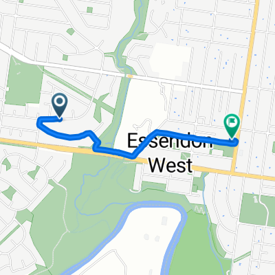
The Boulevard, Essendon West to Shepherd Bridge, West Melbourne
A cycling route starting in Essendon West, Victoria, Australia.
Overview
About this route
- 30 min
- Duration
- 7.7 km
- Distance
- 71 m
- Ascent
- 69 m
- Descent
- 15.5 km/h
- Avg. speed
- 28 m
- Avg. speed

Route quality
Waytypes & surfaces along the route
Waytypes
Cycleway
7.7 km
(99 %)
Quiet road
0 km
(<1 %)
Undefined
0 km
(<1 %)
Surfaces
Paved
7.7 km
(100 %)
Paved (undefined)
4.8 km
(62 %)
Concrete
1.7 km
(22 %)
Continue with Bikemap
Use, edit, or download this cycling route
You would like to ride The Boulevard, Essendon West to Shepherd Bridge, West Melbourne or customize it for your own trip? Here is what you can do with this Bikemap route:
Free features
- Save this route as favorite or in collections
- Copy & plan your own version of this route
- Sync your route with Garmin or Wahoo
Premium features
Free trial for 3 days, or one-time payment. More about Bikemap Premium.
- Navigate this route on iOS & Android
- Export a GPX / KML file of this route
- Create your custom printout (try it for free)
- Download this route for offline navigation
Discover more Premium features.
Get Bikemap PremiumFrom our community
Other popular routes starting in Essendon West
 The Boulevard, Essendon West to Shepherd Bridge, West Melbourne
- Distance
- 7.7 km
- Ascent
- 71 m
- Descent
- 69 m
- Location
- Essendon West, Victoria, Australia
 North Road 76-86, Avondale Heights to Keilor Road 100, Essendon North
- Distance
- 5.9 km
- Ascent
- 63 m
- Descent
- 52 m
- Location
- Essendon West, Victoria, Australia
 brimbank park
- Distance
- 25.3 km
- Ascent
- 105 m
- Descent
- 54 m
- Location
- Essendon West, Victoria, Australia
 72 Military Road, Avondale Heights to 62 Omar Street, Maidstone
- Distance
- 3.3 km
- Ascent
- 34 m
- Descent
- 47 m
- Location
- Essendon West, Victoria, Australia
 2 Riverfront Way, Maribyrnong to Nunn Lane, East Melbourne
- Distance
- 16.6 km
- Ascent
- 0 m
- Descent
- 6 m
- Location
- Essendon West, Victoria, Australia
 Brees Rd, Keilor East to Hoffmans Rd, Essendon West
- Distance
- 1.8 km
- Ascent
- 37 m
- Descent
- 45 m
- Location
- Essendon West, Victoria, Australia
 Aberfeldie to Brimbank Park
- Distance
- 38 km
- Ascent
- 227 m
- Descent
- 262 m
- Location
- Essendon West, Victoria, Australia
 Steele Creek back to Newport
- Distance
- 23.7 km
- Ascent
- 96 m
- Descent
- 129 m
- Location
- Essendon West, Victoria, Australia
Open it in the app