


Karl-Hofmann-Straße 22, Sulzdorf an der Lederhecke nach Karl-Hofmann-Straße 22, Sulzdorf an der Lederhecke
- 13 km
- 188 m
- 191 m
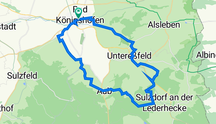
- Bad Königshofen im Grabfeld, Bavaria, Germany
A cycling route starting in Bad Königshofen im Grabfeld, Bavaria, Germany.
Overview
Around Bad Königshofen and the southeastern Grabfeld, countless myths, legends, and tales have always surrounded the area. The best-known story relates to the founding of the town of Königshofen: The queen desperately wishes to accompany her husband on a hunt with his entourage. Accidentally, she loses her wedding ring along the way. When the king learns of this, he becomes very angry and suspects his wife of having intentionally discarded the ring for another lover. To appease her husband, she promises to establish a town at the location where the ring is found and orders her servants to excavate the entire hunting area. Indeed, the ring is discovered, the king and queen are joyfully reunited, and the town of Königshofen is founded. Well, at least according to the legend. Along the route, many other legends abound: they speak of haunted castles, magical springs, and special rock formations that only the devil himself could have created. It’s a tour for all those who might not (any longer) believe in castle ghosts or works of the devil. Because apart from the various legends, the tour also has another charm: relaxed cycling through a picturesque landscape, where the gentle hills of Haßberge gradually slope into the flatter basin of Grabfeld. TourFrom the market square of Bad Königshofen, the tour first passes by the spa park towards the small half-timbered village of Ipthausen. Following the Franconian Saale river, the path then leads along meadows and fields to Unter- and Obereßfeld, to one of the two springs of the Saale. Through shady forests, the route then goes to the Reuthsee, the largest natural lake in Lower Franconia. Passing the impressive Brennhausen castle, the tour finally takes you through the picturesque landscape of Grabfeld, returning through dreamy villages back to Bad Königshofen. Tips and additional informationStartWe recommend starting this tour at the market square of Bad Königshofen. Since it is a circular route, you can of course join in anywhere along the route.RefreshmentUnfortunately, there is no opportunity to stop for refreshments on this tour. Therefore, we recommend packing supplies for the journey. The Reuthsee is ideal for a small picnic. Back in Bad Königshofen, you will find multiple dining options again. Please check the current opening times in advance.Explorer GuideYou can find the full story about the queen's ring and the founding of Königshofen in our digital explorer guide!
created this 2 years ago
Route quality
Track
19.7 km
(71 %)
Quiet road
3.3 km
(12 %)
Paved
15 km
(54 %)
Unpaved
9.7 km
(35 %)
Asphalt
12.8 km
(46 %)
Gravel
6.4 km
(23 %)
Continue with Bikemap
You would like to ride Der Ring der Königin or customize it for your own trip? Here is what you can do with this Bikemap route:
Free trial for 3 days, or one-time payment. More about Bikemap Premium.
Discover more Premium features.
Get Bikemap PremiumFrom our community
Open it in the app


