
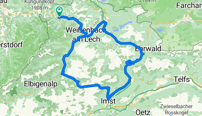
Tannheim-Hahntennjoch-Tannheim
A cycling route starting in Tannheim, Tyrol, Austria.
Overview
About this route
Radtour über den Fernpass und das Hahntennjoch.
- -:--
- Duration
- 135.9 km
- Distance
- 3,161 m
- Ascent
- 3,261 m
- Descent
- ---
- Avg. speed
- 1,906 m
- Avg. speed
Route quality
Waytypes & surfaces along the route
Waytypes
Busy road
100.7 km
(74 %)
Road
16 km
(12 %)
Surfaces
Paved
115.4 km
(85 %)
Unpaved
4.3 km
(3 %)
Asphalt
114.5 km
(84 %)
Unpaved (undefined)
2.5 km
(2 %)
Continue with Bikemap
Use, edit, or download this cycling route
You would like to ride Tannheim-Hahntennjoch-Tannheim or customize it for your own trip? Here is what you can do with this Bikemap route:
Free features
- Save this route as favorite or in collections
- Copy & plan your own version of this route
- Sync your route with Garmin or Wahoo
Premium features
Free trial for 3 days, or one-time payment. More about Bikemap Premium.
- Navigate this route on iOS & Android
- Export a GPX / KML file of this route
- Create your custom printout (try it for free)
- Download this route for offline navigation
Discover more Premium features.
Get Bikemap PremiumFrom our community
Other popular routes starting in Tannheim
 Radltour in Tannheim
- Distance
- 50.8 km
- Ascent
- 289 m
- Descent
- 513 m
- Location
- Tannheim, Tyrol, Austria
 Vorarlbergrunde
- Distance
- 166.2 km
- Ascent
- 2,190 m
- Descent
- 2,190 m
- Location
- Tannheim, Tyrol, Austria
 Tour 2013 Auf König LudwigsSpuren mittel
- Distance
- 69.8 km
- Ascent
- 666 m
- Descent
- 666 m
- Location
- Tannheim, Tyrol, Austria
 Tannheim-Pronten-Reutte-Berwang-Namlos-Tannheim
- Distance
- 105 km
- Ascent
- 1,011 m
- Descent
- 1,012 m
- Location
- Tannheim, Tyrol, Austria
 Tannheim Jungholz Tannheim
- Distance
- 40.2 km
- Ascent
- 459 m
- Descent
- 460 m
- Location
- Tannheim, Tyrol, Austria
 Tour 2013 Namlosrunde Schwierigkeitsgrad mittel
- Distance
- 74.5 km
- Ascent
- 947 m
- Descent
- 951 m
- Location
- Tannheim, Tyrol, Austria
 Tannheimer Tal - Radmarathon
- Distance
- 225.8 km
- Ascent
- 2,320 m
- Descent
- 2,321 m
- Location
- Tannheim, Tyrol, Austria
 Tour Strinden Alpe
- Distance
- 23.7 km
- Ascent
- 948 m
- Descent
- 948 m
- Location
- Tannheim, Tyrol, Austria
Open it in the app