

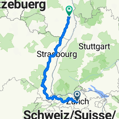
Heinrichstrasse 225, Zürich to Limmatfeld Strasse 2, Dietikon
A cycling route starting in Zürich (Kreis 5), Canton of Zurich, Switzerland.
Overview
About this route
- 31 min
- Duration
- 9.9 km
- Distance
- 24 m
- Ascent
- 73 m
- Descent
- 19.2 km/h
- Avg. speed
- 437 m
- Avg. speed

Route quality
Waytypes & surfaces along the route
Waytypes
Path
3.5 km
(35 %)
Pedestrian area
3 km
(31 %)
Surfaces
Paved
9 km
(91 %)
Unpaved
0.2 km
(2 %)
Asphalt
8.7 km
(88 %)
Pebblestone
0.2 km
(2 %)
Continue with Bikemap
Use, edit, or download this cycling route
You would like to ride Heinrichstrasse 225, Zürich to Limmatfeld Strasse 2, Dietikon or customize it for your own trip? Here is what you can do with this Bikemap route:
Free features
- Save this route as favorite or in collections
- Copy & plan your own version of this route
- Sync your route with Garmin or Wahoo
Premium features
Free trial for 3 days, or one-time payment. More about Bikemap Premium.
- Navigate this route on iOS & Android
- Export a GPX / KML file of this route
- Create your custom printout (try it for free)
- Download this route for offline navigation
Discover more Premium features.
Get Bikemap PremiumFrom our community
Other popular routes starting in Zürich (Kreis 5)
 From Zurich to Großkarlbach
- Distance
- 480.8 km
- Ascent
- 4,474 m
- Descent
- 4,760 m
- Location
- Zürich (Kreis 5), Canton of Zurich, Switzerland
 Cirih Bec
- Distance
- 917.1 km
- Ascent
- 7,111 m
- Descent
- 7,332 m
- Location
- Zürich (Kreis 5), Canton of Zurich, Switzerland
 Hardstrasse, Zürich nach Hardstrasse 252, Zürich
- Distance
- 0.2 km
- Ascent
- 0 m
- Descent
- 0 m
- Location
- Zürich (Kreis 5), Canton of Zurich, Switzerland
 ZKB - Zllikerberg - Forch - Herrliberg
- Distance
- 28.3 km
- Ascent
- 486 m
- Descent
- 433 m
- Location
- Zürich (Kreis 5), Canton of Zurich, Switzerland
 Zürich - Winterthur über Kyburg
- Distance
- 30.7 km
- Ascent
- 406 m
- Descent
- 365 m
- Location
- Zürich (Kreis 5), Canton of Zurich, Switzerland
 Limmattal Runde
- Distance
- 54.2 km
- Ascent
- 814 m
- Descent
- 814 m
- Location
- Zürich (Kreis 5), Canton of Zurich, Switzerland
 Zürich - Greifensee - Pfannenstiel - Zürichsee
- Distance
- 55.1 km
- Ascent
- 453 m
- Descent
- 455 m
- Location
- Zürich (Kreis 5), Canton of Zurich, Switzerland
 Zürich - Wintertthur über Gyrenbad (Turbenthal)
- Distance
- 45.7 km
- Ascent
- 549 m
- Descent
- 508 m
- Location
- Zürich (Kreis 5), Canton of Zurich, Switzerland
Open it in the app