2011-11-06 La Gomera
A cycling route starting in Alajeró, Canary Islands, Spain.
Overview
About this route
Urlaubsrunde mit gemietetem Mountainbike (mit Straßenbereifung) aus dem "Basislager" in La Calera im Valle Gran Rey hoch in das Bergdorf Chipude auf 1100m, anschließend 16km Abfahrt zur Südküste an die Bucht La Rajita. Nach Erkundung dieses Lost Places (ehem. Konservenfabrik) und idylischen Badeplatzes wieder 2h lang hoch nach Chipude. 2 Cortados später noch eine kleine Runde über die gerade mal wolkenfreie Nationalparkstraße (Hmax. 1350m) und dann in endloser Abfahrt zurück ins Valle Gran Rey.
Temperatur unten 25°C, oben 14°C, sonnig, Föhnwind aus Nordost, kaum Autoverkehr; schöner kann man nicht Radfahren. Danke nochmal an das Team von Gomera-Bikes!
- -:--
- Duration
- 87.5 km
- Distance
- 2,373 m
- Ascent
- 2,423 m
- Descent
- ---
- Avg. speed
- ---
- Avg. speed
Route highlights
Points of interest along the route

Point of interest after 25.4 km
Wieder oben angekommen, am Fuße des Tafelberges La Fortaleza kurz vor dem Bergdorf Chipude (1100m)

Point of interest after 36.8 km
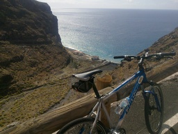
Blick hinunter zur Bucht La Rajita mit den verlassenen Gebäuden einer ehemaligen Konservenfabrik (200m).
Point of interest after 36.8 km

Point of interest after 38.6 km
Der alte Anleger in der Felsenbucht von La Rajita

Point of interest after 42.9 km
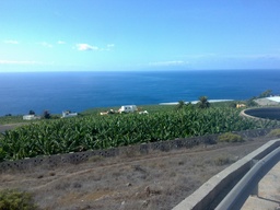
Blick über die Bananenplantagen von La Dama (300m).

Point of interest after 46.4 km
Blick über die kargen Südhänge hinauf zur La Fortaleza.

Point of interest after 60.4 km
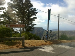
Der höchste Punkt der Tour (1350m) am Mirador de Igualero - im Hintergrund La Fortaleza "von oben".
Continue with Bikemap
Use, edit, or download this cycling route
You would like to ride 2011-11-06 La Gomera or customize it for your own trip? Here is what you can do with this Bikemap route:
Free features
- Save this route as favorite or in collections
- Copy & plan your own version of this route
- Sync your route with Garmin or Wahoo
Premium features
Free trial for 3 days, or one-time payment. More about Bikemap Premium.
- Navigate this route on iOS & Android
- Export a GPX / KML file of this route
- Create your custom printout (try it for free)
- Download this route for offline navigation
Discover more Premium features.
Get Bikemap PremiumFrom our community
Other popular routes starting in Alajeró
 La Gomera (Valle Gran Rey -> Playa Santiago -> Valle Gran Rey
- Distance
- 98.4 km
- Ascent
- 2,813 m
- Descent
- 2,815 m
- Location
- Alajeró, Canary Islands, Spain
 Gomera
- Distance
- 96 km
- Ascent
- 3,139 m
- Descent
- 3,139 m
- Location
- Alajeró, Canary Islands, Spain
 La gomera 2
- Distance
- 16.4 km
- Ascent
- 92 m
- Descent
- 1,456 m
- Location
- Alajeró, Canary Islands, Spain
 La Gomera
- Distance
- 142.2 km
- Ascent
- 3,965 m
- Descent
- 3,915 m
- Location
- Alajeró, Canary Islands, Spain
 MTB Gran Valle Ray - Alojera
- Distance
- 18.2 km
- Ascent
- 1,035 m
- Descent
- 1,049 m
- Location
- Alajeró, Canary Islands, Spain
 Avenida Marítima, 2A, Alajeró to Etapa 8: Playa de Santiago-San Sebastián de la Gomera, San Sebastián de la Gomera
- Distance
- 11.7 km
- Ascent
- 561 m
- Descent
- 420 m
- Location
- Alajeró, Canary Islands, Spain
 RUTA 2 VGR_SSG
- Distance
- 76.1 km
- Ascent
- 2,035 m
- Descent
- 2,073 m
- Location
- Alajeró, Canary Islands, Spain
 2011-11-06 La Gomera
- Distance
- 87.5 km
- Ascent
- 2,373 m
- Descent
- 2,423 m
- Location
- Alajeró, Canary Islands, Spain
Open it in the app


