

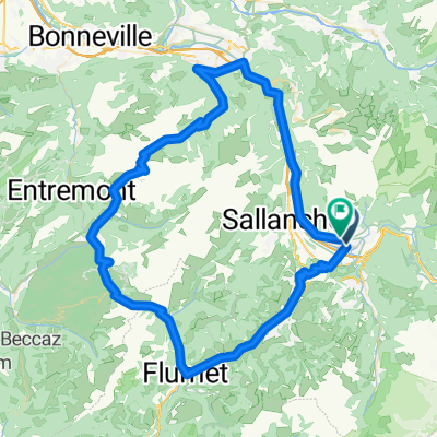
lac vert -passy-armancette
A cycling route starting in Passy, Auvergne-Rhône-Alpes, France.
Overview
About this route
- 1 h 32 min
- Duration
- 21.1 km
- Distance
- 668 m
- Ascent
- 597 m
- Descent
- 13.7 km/h
- Avg. speed
- 1,186 m
- Avg. speed
Route quality
Waytypes & surfaces along the route
Waytypes
Road
10.7 km
(51 %)
Quiet road
7.2 km
(34 %)
Surfaces
Paved
17.8 km
(84 %)
Unpaved
0.1 km
(<1 %)
Asphalt
17.8 km
(84 %)
Gravel
0.1 km
(<1 %)
Undefined
3.2 km
(15 %)
Continue with Bikemap
Use, edit, or download this cycling route
You would like to ride lac vert -passy-armancette or customize it for your own trip? Here is what you can do with this Bikemap route:
Free features
- Save this route as favorite or in collections
- Copy & plan your own version of this route
- Sync your route with Garmin or Wahoo
Premium features
Free trial for 3 days, or one-time payment. More about Bikemap Premium.
- Navigate this route on iOS & Android
- Export a GPX / KML file of this route
- Create your custom printout (try it for free)
- Download this route for offline navigation
Discover more Premium features.
Get Bikemap PremiumFrom our community
Other popular routes starting in Passy
 Passy-chamonix
- Distance
- 26.7 km
- Ascent
- 912 m
- Descent
- 437 m
- Location
- Passy, Auvergne-Rhône-Alpes, France
 De Avenue Léman Mont-Blanc 170, Passy à Hameau des Fiz 140, Passy
- Distance
- 54.2 km
- Ascent
- 519 m
- Descent
- 522 m
- Location
- Passy, Auvergne-Rhône-Alpes, France
 balade tour des lacs
- Distance
- 8 km
- Ascent
- 37 m
- Descent
- 37 m
- Location
- Passy, Auvergne-Rhône-Alpes, France
 Passy 2012
- Distance
- 103.6 km
- Ascent
- 1,992 m
- Descent
- 1,987 m
- Location
- Passy, Auvergne-Rhône-Alpes, France
 De Chemin des Parchets 324, Passy à Chemin des Parchets 350, Passy
- Distance
- 0.1 km
- Ascent
- 0 m
- Descent
- 0 m
- Location
- Passy, Auvergne-Rhône-Alpes, France
 Passy - Colombière
- Distance
- 96.1 km
- Ascent
- 1,990 m
- Descent
- 1,877 m
- Location
- Passy, Auvergne-Rhône-Alpes, France
 passy - combloux
- Distance
- 22.4 km
- Ascent
- 667 m
- Descent
- 273 m
- Location
- Passy, Auvergne-Rhône-Alpes, France
 Passy - Reserve de Passy
- Distance
- 19.5 km
- Ascent
- 1,399 m
- Descent
- 111 m
- Location
- Passy, Auvergne-Rhône-Alpes, France
Open it in the app